Visit Map

Sunday, 11 September 2016

Bridges near Thomson on the Moe Walhalla Railway

Finally, back bothering bridges again after a lengthy period of trying to tend to business. I had developed a very large backorder and at the same time, there were lots of chores to do around the farm. But it is mostly under control now, so off I went.

Today I travelled to Thomson on the Moe to Walhalla Railway, to look at two bridges just on the south side of Thomson. These bridges were timber piers with iron spans, one bridge on a curve with 7 openings and a straighter bridge of 5 openings, closest to Thomson. When I refer to the number of openings, these are the iron spans only. The Walhalla Goldfields Railway refers to these bridges as bridges 9 and 10, although the logic in this is puzzling, as normally bridges are numbered from the start of the line, while these bridges appear to ignore that convention.

Darren Hodges had photographed these two bridges back in the 1990s when the bush was not as thick as it now is, and I wanted to see how they fared today. This is a map of the bridges:


The Thomson Station precinct is shown in the green shaded area, with the two bridges highlighted in red and blue. They are only a very short walk from the station. For safety reasons, a track has been built around the bridge sites, and upon examining the area, I could not find any trace of the 5 opening bridge, marked in red, Bridge 9. It is possible that someone more adventurous could have bashed their way through the undergrowth, but I don't take chances like that these days. I could see down from the foot track to some extent, but could not see the bridge at all.

The larger 7 opening bridge, bridge 10 is still intact, but almost impossible to get good photos of due to dense undergrowth. 


Georgia the Gunzel Spaniel is again out and about with me, having just been down the hill and back again, more capable than I. One thing I noticed is that the nearest iron span has had the cross braces cut by gas torch, this is why the left beam, near Georgia, has dropped. Apparently this was done back in the 70s or 80s in order to stop trail bike or 4WD people from driving across the bridges.


The next two shots show what may be the iron spans from the apparently missing 5 opening bridge. They look very much like the ones on the 7 opening bridge, and co-incidentally, there are 5 of them stacked up in the WGR yard at Thomson. According to the WGR web site, bridge 9 has been removed, so it is a fair bet that these are the iron spans from that bridge, safely stored for the future.


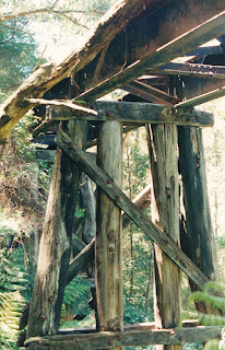
Finally, a set of seven photos taken by Darren Hodges back in the 1990s when the bush was not as dense. 

Photo by Darren Hodges

Photo by Darren Hodges

Photo by Darren Hodges

Photo by Darren Hodges

Photo by Darren Hodges

Photo by Darren Hodges
I think the above photo shows the shorter 5 opening bridge, #9, the one I could not locate.

Photo by Darren Hodges


Saturday, 30 July 2016

Nothing New on Here?

Unfortunately I have been very busy with the Hollywood Foundry business for some months now. The development of an eye cataract made it very difficult to work and I got well behind on orders. I have since had the cataract removed, but there are still a lot of orders waiting to be assembled. One side effect of having the cataract removed is that it was colouring my vision with a strong yellow tint, and I now find all my meticulous colour grading is completely wrong.

When Spring comes and I can get the orders under control, I hope to get out and cover some more bridges - plenty more to go!

Friday, 25 March 2016

Bridges over Murray River Billabongs - Robinvale To Lette Railway

You could easily be forgiven for wondering what I am referring to here, as few people were aware that a railway was constructed from Robinvale to Lette in New South Wales. And strictly speaking, there was not one. It was planned in 1922, but was only completed as far as Koorakee. 

Work started in 1926 and it reached Koorakee in 1930. This was celebrated by a special train. Work continued towards Lette, but was never completed. The line was never officially opened and was operated by the Railway Construction Branch until construction was officially abandoned on 12 February 1943. The rail-road bridge was replaced in 2006 by a new road bridge.

Ken Littlefair was involved in the work on the new bridges and roadway of the Murray Valley Highway on the Euston (NSW) side of the line and took the following photos which he has kindly made available.

From available information, there were only two bridges on the line, the large combined road and rail lift bridge over the Murray River itself and these ones over a billabong. 

The bridge over the Murray was demolished in 2006 when the new bridge was built, but the lift span section has been preserved in a local park at the northern end of the Robinvale rail yard, on the corner of the Murray Valley Highway and Moore Street.


Photo by Ken Littlefair

Photo by Ken Littlefair

Photo by Ken Littlefair

Photo by Ken Littlefair

Photo by Ken Littlefair

Friday, 11 March 2016

Bridge over Merran Creek near Stony Crossing - Murrabit to Stony Crossing Line.

This was the last crossing of Merran Creek by the railway, just short of the terminus at Stony Crossing. 

This photo was taken by Des Jowett while flying along the line. Actually pretty obvious when you see the aircraft wing in the shot.


Photo by Des Jowett

Des Writes: This B&W shot was taken when a mate & I drove there when the line was intact and we planned to try and follow the line along dirt tracks. Down came the rain and that put paid to our plans as my Austin Lancer would have gone down in the mud.  The line was dismantled in 1961 back to Murrabit, and Murrabit to Kerang closed in 1964 when the  Barr Ck bridge collapsed under a small train - luckily the J and it's train remained on the track but the van was on the saggy portion.

The photo was taken on September 9, 1958.

Photo by Des Jowett


Bridge 1 over Larrys Creek - Murrabit to Stony Crossing Line.

This bridge is shown in the VR grades book as being over Nerran Creek, which these days is named Merran Creek, however looking at the maps, the section of creek is now isolated and called Larry's Creek. 

This is another photo by Des Jowett, taken from a light aircraft while flying along the route of the line. 

Photo by Des Jowett

Bridge over Coobool Creek (Merran Creek) - Murrabit to Stony Crossing Line.

Bridge over Coobool Creek (Merran Creek) - Murrabit to Stony Crossing Line. This bridge is listed in the VR grades book as being over Coobool Creek, although these days it is shown as Merran Creek. 

This photo was kindly contributed by Des Jowett. Des took the shot from a light aircraft flying over the line, and is cropped from a wider shot.

The bridge still appears to be in existence today.


Photo by Des Jowett

Thursday, 10 March 2016

Murrabit Bridge over Murray River - Stony Crossing Line.

Des Jowett writes: The shot of Murrabit Bridge shows the last remaining bit of rail on the Stony Crossing line on the approach road to the lift span on the NSW side.


Wednesday, 9 March 2016

Lancefield Town Platform - Clarkefield to Lancefield Line.

This entry was kindly contributed by Des Jowett. Des writes:


Here is a shot of the Lancefield Town platform. You can see the ramped  end but the wooden facing has been removed. 

Photo by Des Jowett

Ever since the line to Lancefield was opened in June 1881, the locals wanted the line extended a bit closer to the centre of the town. With the building of the Lancefield-Kilmore line the opportunity was taken to build a platform near the rear of the Macedonia Hotel with an access pathway to the street. The Lancefield - Kilmore line opened on 6-4-1892 and arrangements were made that from June 1, 1892, trains would run to and from the Town platform, for trains departing the platform it was ten minutes before the departure time from the main Lancefield station, where the train then stopped for passengers from the Town station to purchase their tickets. There is no record of how long the Town platform was in use for; the PMG replaced the Mail Box there in August 1895 after the station building had been removed, so perhaps it closed with the 1897 first closure of the Lancefield-Kilmore line.  In 1917 a firewood loading site was established at this location.


Here is a shot of a 280hp Walker railmotor stabled at Lancefield right down over the two bridges and near the Town platform site. The date was April 19, 1954 and it formed the afternoon Up service to Melbourne on a public holiday. I think they ran it way down there to get it out of the way of a goods train.


Photo by Des Jowett

Bridge over Access Road at Lancefield Station - Clarkefield to Lancefield Line

From Des Jowett. I have found another old bridge at Lancefield that was the road access to the station ground on the eastern side of the station. It was between the station and the old creek bridge, and cut through the embankment. This photo was taken on 28-9-1986 by which time the deck had been removed and the opening filled in. You can still just see the remains of the roadway curving towards the bridge opening on Google Maps view.

Photo by Des Jowett
Thank you Des.

Thursday, 11 February 2016

Bridge over Tanjil River - Moe to Walhalla Narrow Gauge Railway.

The bridge over the Tanjil River was only about 1.2 kilometres north of the La Trobe River Bridge. The track was carried between the two bridges on a slightly raised causeway, crossing the Tanjil River on a wooden bridge, then across the river flats on the northern side for approximately 150 Metres. At the end of the bridge section, the line entered into a deep cutting before emerging onto the more or less flat section on the other side of the hill. Near the peak of the hill, the original Moe to Walhalla Road crossed the track by a wooden road over rail bridge. The bridge section consisted of 29 openings of 20 feet, plus one steel span of 40 feet.

There is not a lot to be seen these days, although I was prompted to visit the site by Darren Hodges providing a photo taken in the early 1990s. In this photo, the bridge is almost gone completely, the cutting having been largely filled in, as you can see to the left. However the bridge railing is still visible along with the posts. The nearest post is a datum post, and is still there today, see next:


Photo by Darren Hodges

This photo was taken today, and I framed as near as possible to the original. Note the Datum post still in place. Now there are only two posts left in the ground, but the rails have been removed for safe-keeping and are stored on the road to the right side. I am told the rails will be placed back in position in the future.

But a lot more has changed, most notably the house in the background has been replaced by a newer dwelling. Interestingly, it is still in the hands of the same family, the grandson of the previous house owner is now living in the new house with his family. They were very kind in allowing me access to their land to photograph the bridge remains. The land around the cutting has been tidied up and even more of the cutting filled in. In fact, you really cannot see any trace of the old cutting anywhere.

The roadbed in both photos is the original Moe - Walhalla Road, now diverted to the right side of the old road and at a lower level.


A closer view of the datum post, clearly showing its age. Note the slots where the bridge rails were fitted.


A view looking down the line of the missing cutting.


View from what would have been the northern end of the bridge across the river flats. The inclined posts of the fence going towards the river are in fact the western side piers of the bridge, now utilised as a fence.


Down at river flat level, the bridge piers heading south towards the Tanjil River.


At the river itself, a view across at the bridge abutment on the southern side.


From the southern side of the Tanjil River, looking back towards the house. Just visible in the river is the concrete footing of one of the bridge piers, then the line of piers in the distance.


Here is another of Darren Hodge's photos from the 1990 period, taken in the same direction as the above photo. However the original farmhouse is there, more of the piles are evident and you can just see a little more of the filled in cutting.

Photo by Darren Hodges
The aforementioned pier footing in the river.


Looking south along the causeway towards the La Trobe River bridge. The objects in the foreground have nothing to do with the bridge. The family who own this land are/were associated with the nearby Moe Abattoirs and bought the ROW some years ago and have used it to store excess equipment from the meatworks. There is still a lot of this machinery stored further down the causeway.


The following group of photos come from the book by Stephen Watson, "Walhalla Railway Bridges". They show the Tanjil River bridge as it was when the line was running.

Taken from North West corner showing a Moe bound train about to cross the Tanjil River


Looking South from the Farmhouse area towards the river.


Taken on Western side showing train heading towards Moe, the Na locomotive is over the steel span.


A train also heading towards Moe, in much the same position as the previous photo, except it is taken on the East side of the bridge, looking West.


Looking towards Moe, taken from the North East corner.


The Road bridge over the line, just North of the farmhouse. Looking towards Moe (yet again).


Sunday, 17 January 2016

Jeparit - Yanac Branch - Bridge over Wimmera River at Jeparit.

The bridge is still in existence over the Wimmera River, although the aerial view appears to show it without decking. It is to the west of the township of Jeparit, crossing the Wimmera River a short distance before the river empties into Lake Hindmarsh. I have this bridge marked for a visit to photograph it, having missed out on the opportunity when shooting the bridge at Quantong. 

However I have some photos from Allan Renshaw showing an ARHS special pulled by J 508 crossing the bridge in September 1966.

Photo by Allan Renshaw. From the collection of Darren Hodges