Visit Map

Wednesday, 24 November 2021

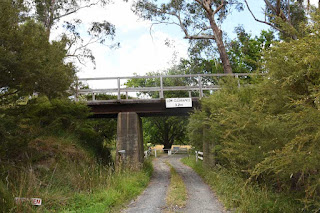
Cattle Underpass near Woori Yallock Creek. Lilydale to Warburton Railway.

Built using the same recipe as all the other bridges along this line, this consists of four concrete piers and steel beams. 

It is just short of the larger Woori Yallock Creek bridge.


Bridge over Woori Yallock Creek, Woori Yallock. Lilydale to Warburton line.

 A low bridge of steel beams over concrete piers, across the Woori Yallock Creek and it's large surrounding wetlands. It is very likely that this bridge is original, and simply re-decked to make it suitable for a rail trail. It is approximately 176 Metres long, with a second section of 55 Metres. 


An oblique view , North side of bridge, looking East towards Warburton.


The main part of the Woori Yallock Creek, rather full and free flowing. View from South side of bridge, looking East towards Warburton.


Complimentary view from the North side of the creek.


Monday, 22 November 2021

Road over Rail Bridge, Private Access road at Woori Yallock, Lilydale to Warburton Railway

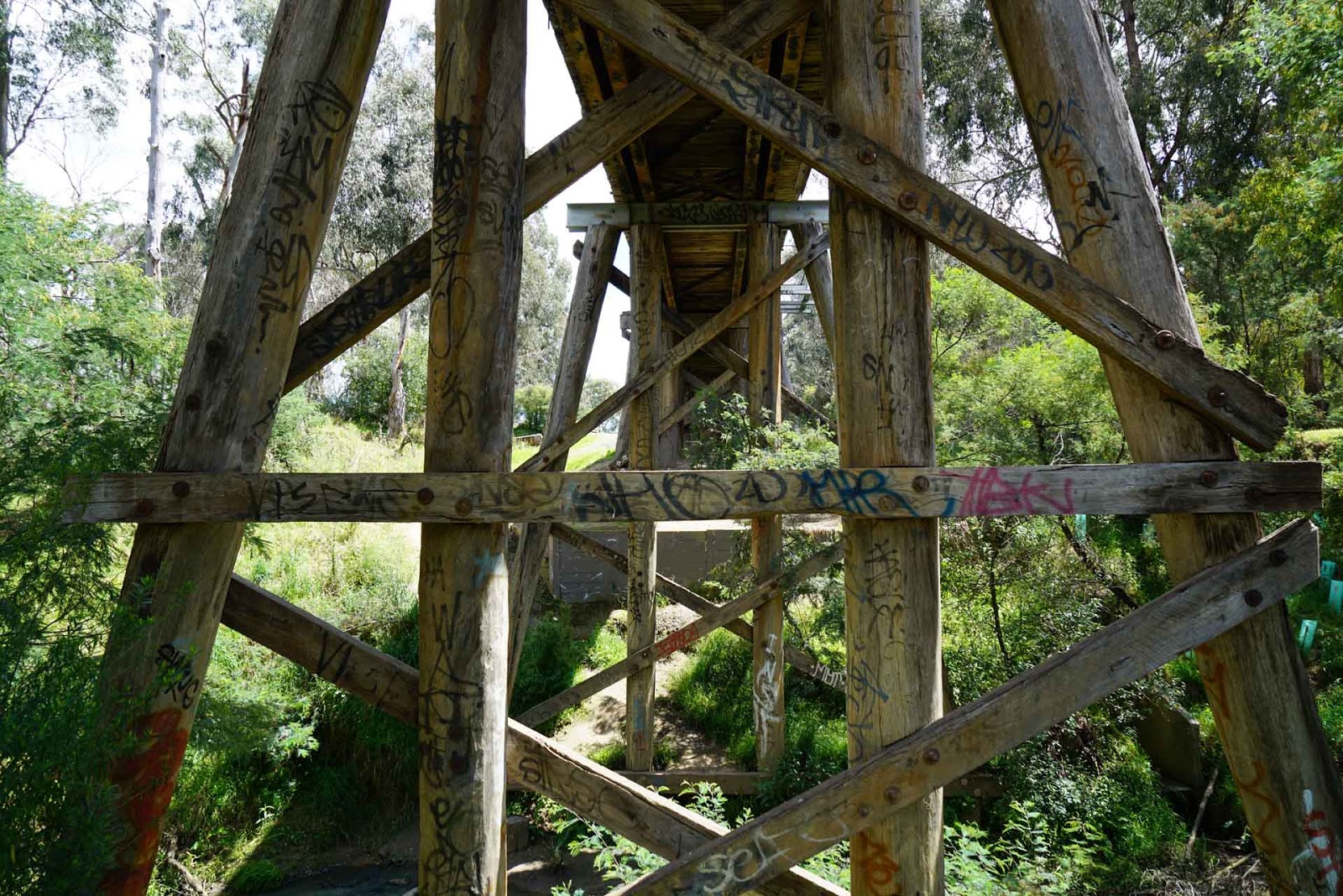
 This bridge appears to be pretty original. It has steel I beam spans spans on wooden trestles and does not appear to have been 'gentrified' for the conversion of the ROW to a rail trail. It is protected from stock crossing at either end by cattle grids. On the other hand, it may have been modified from wooden spans to steel spans at an earlier time. 


View looking towards Warburton.


View of underside detail.


Rail over Road Bridge, Kylie Lane, Seville East. Lilydale to Warburton Railway

Finally out of lockdown and out on the trails again. This time being the first outing for the new bicycle. I had bought a folding mountain bike to ride the trails, but after my cardiac surgery, I found it stressful riding any distance. So I bought a conversion kit and converted the bike into an e-Bike. 

I drove to the car park at the old Woori Yallock station, then rode back towards the west to access this bridge, and others along the Warburton Rail Trail.

This bridge is pretty unremarkable, being steel beams on concrete piers, with 3 openings. Pretty much all of the bridges on the old Lilydale to Warburton line are of similar construction. This bridge allows Kylie Lane to pass under the rail line. I called out to Kylie, but she did not answer, must have been off enjoying the lovely Spring weather :-)


Looking along the rail trail towards Warburton.


View of Kylie Lane on the North side of the bridge.


It was too steep to get down to the roadway, so this view is the best I could manage from the ROW.


Fortunately, Deon drove along Kylie Lane and sent me this photo showing the bridge from gound level. Thank you Deon.


Friday, 22 October 2021

Bridge over Percival Creek south of Pyalong - Heathcote Junction to Bendigo Line.

Hooray, finally able to break out of the COVID restrictions, and get on the road again. It has been so long, I forgot how to perform some of the trickier drone maneuvers and also the editing of this blog.

But finally able to go out with the express purpose of investigating this very interesting bridge.  I found this bridge originally using Google Earth, by speculating that there should be a bridge  at this location, even though the aerial view did not clearly show one there. The fact that there was a creek here pointed to the possibility of a bridge, but it could not be seen.

By using Google Earth instead of the normal Google Maps view, there is a history tool that allows you to rewind the date of the aerial views, and when I wound it back, lo and behold, there was the bridge. As it turns out, a long held friend of mine, John, moved to Pyalong earlier this year, and I was able to get him to affirm the presence of the bridge.

The bridge is quite substantial, it is an estimated 85 Metres long with 19 openings, and is actually in better condition than the better-known bridge over Mollison's Creek, in town. The date on the timbers at the north end suggest that the last maintenance work was carried out in 1949. Like all abandoned wooden bridges, the deck timbers have rotted through in a about 3 places (at time of examination) and there are prominent signs posted warning people not to walk under the structure, plus wire barriers at the abutments to try and keep people off the deck. Otherwise, the bridge is more or less intact.

The people on the adjacent property on the west side claim that they lease the land that the bridge is on, and are a bit sensitive about people wandering onto the site. We found a convenient parking spot on the highway within about 100 Metres of the bridge, just next to an 'Overtaking Lane 400M' sign. 

The following photos are taken at the north end of the bridge on the west side, looking back towards Heathcote Junction.


Pyalong - Third bridge, dismantled - Heathcote Junction to Bendigo Line.


My friend John, who lives in Pyalong, had been told by the publican at the Pyalong Hotel, that originally there had been 3 timber bridges in the district, but I had only managed to locate 2 of them. Fortunately, John had found this one on his daily walk routine.

There is almost nothing left of the bridge, it had been extensively excavated, in fact the excavator is still beside the bridge.

This appears to be an example of where a bridge was filled in as an embankment, then later on the local farmer has dug it out again, exposing the bridge remains. This was presumably done to allow stock to move more easily from one side to the other.

According to the VR Grades book, this bridge was originally 6 openings of 15 foot, plus one opening of 20 feet.


Wednesday, 23 October 2019

I had a lovely email from a fellow bridge enthusiast and photographer today, who noted that the last entry was in September of 2018, and asking if I had given up on adding to the blog. 

The answer is no, I hope to be out and about again very soon. This last year has seen some challenges, the surgery on my back has worked, however I am finding it hard to get out. At the same time, we moved from our property in Garfield in West Gippsland, to a lovely new place at Jindivick, just north of Warragul. The move to the new property has meant I have had to spend some time adapting the place to our needs, but that is mostly done now.

The upside is that I am now even closer to the site of the most magnificent chain of wooden bridges between Nayook and Noojee. They are almost in my backyard. I spent many weeks with these bridges back in 1962, and the memories of them are still quite alive for me. Sadly, apart from the well known preserved bridge, there is almost nothing remaining of the best of those bridges.

Thank you for looking in, and see you out in the bush....

Sunday, 9 September 2018

Bridge #1 over Stringybark Ck. on the Lilydale to Healesville Line

First bridge of any interest after Lilydale. It consists of eleven 11 feet openings and a longitudinal deck.. It is badly infested with reeds and blackberries and not very easy to access or photograph. Sadly, rather unattractive. 

Heading from Lilydale to Healesville, via Yarra Glen, this is the first bridge of any interest on the line but situated beside a very busy road where it is not advised to stop for a photo, as there is no place to stop or park off the highway.


Bridge #2 on the Lilydale to Healesville Line

My numbering, nothing to do with the railway. This bridge is probably the most interesting one left on this railway line, and the most easily accessed and visible. 

It consists of ten 15 foot openings plus a single central 20 foot opening. I am guessing it's purpose was simply to let water through under the rail line. Apparently this bridge is known as the 'Humpback Bridge' because the middle is higher than the ends.

It is situated alongside the Melba Highway, 8.92 Kilometres from Lilydale Station. 

It is in pretty poor condition, consistent with being abandoned for many years. 


Bridge #3 on Lilydale to Healesville Line

It is not any sort of official numbering, it simply means the third interesting bridge on the line from Lilydale. It is located just at the point where the line spears off across the Yarra River flood plain towards Yarra Glen, departing from the Melba Highway. 

About the Melba Highway. The day I was there I was quite concerned about being wiped out by the incessant traffic, particularly tip trucks, that buzz along that road. It is not a good place to stop for photographs.

This is the last remaining wooden section of what was once a very long and impressive set of bridge sections that crossed the Yarra River flood plain. The trestle sections have been replaced over the years by earthern embankment, and in the accompanying video, you can see where the earth was excavated from long trenches beside the line, now filled with water.

Much of the wooden sections, including the river crossing, were wiped out by bushfires. 

The remaining bridge consists of five 11 foot openings.


Bridge over Simpsons Lane - Lilydale to Healesville Line

I should amend that title, it is not a bridge, but a concrete culvert. It would seem that if you run a 'Heritage Railway' you do not have any obligation to preserve the heritage part of it. 

There was once a quite respectable wooden trestle bridge across Simpsons Lane, but it has now been replaced by a bog ugly concrete culvert and fill on either side. When David Foulkes and I inspected the wooden bridge, just after the disastrous fires, the only damage to the bridge was a single burnt out pile. I would have thought that would have been a reasonably easy repair rto make. The bridge was lucky to have survived, because the fire burnt out all the wooden sleepers on the Healesville side of the bridge. Even at that time, Simpsons Lane bypassed the bridge, now the culvert seems to simply be there as a drainage measure. 

Anyhow, this is how it looked then.


This is the ugly scene these days. Very disappointing. 


New construction bridges on Lilydale to Healesville Line

Just to tie up loose ends, here is a photo of one bridge, close to Yarra Glen, that is typical of the approximately 11 bridges that were originally of wooden construction, but have been replaced by a steel and concrete design. The original bridges were either destroyed or damaged by fire, and were replaced in a pre-emptive strike to save them causing problems in the event of future fires. 


Bridge over Lilydale to Healesville Line at Donovans Road

This is a road-over-rail bridge that once carried Donovans Road over the Lilydale to Healesville railway line, approximately 1.8 Kilometres short of the line's destination at Healesville. It is not in use any longer, having been rendered obsolete by a small road diversion to the west of the bridge to take Donovan's Road across the tracks at grade level. 

Standing looking at the current arrangement, one is tempted to wonder why the crossing at grade was not implemented originally, as it only involves a short deviation to the road along what probably would have been railway land anyway.

The bridge is in quite surprisingly good condition, although I would not like to stroll across the deck (I have a strict rule about not strolling across bridge decks in order to prolong life). I would suspect that it has to be very carefully maintained so bits of it do not fall onto the permanent way. 

The bridge is at the top of a rise in the track level, with the track gently sloping down either side of the bridge.


The northern end of the deck.


The western approach to the bridge, looking towards Healesville, up the small grade.


South end from track level.


North end from Track level.


Underside of deck.


Eastern approach to the bridge, looking towards the new grade crossing, again down grade.


Sunday, 5 November 2017

Bridge over Diamond Creek at Eltham

In something of a break with tradition, I decided to cover this bridge even though it is on a fully operational line, and not abandoned. My reasoning is that the bridge is something of a dinosaur, being almost entirely wood in its construction and being used by high-frequency suburban trains. 

I figure it is only a matter of time before someone shrieks out in horror that 'the public is in great danger as long as Metro allows this ancient and unsafe bridge to be used'.

Of course those among us know that a properly maintained, and well constucted wooden bridge is perfectly adequate for the relatively light loads of suburban electric stock, but that probably won't stop a full-blown outbreak of ignorant hysteria. 

The bridge is entirely wooden for its full length of 195 Metres, except for two steel sections supporting the spans across Diamond Creek itself. There are 34 x 15 foot spans, plus 4 x 30 foot spans in the bridge. The remaining spans have wooden beams with transverse decking, and classic gravel beams with tie rods, wooden sleepers and ballasted rail. In several places, the piers have steel I beam crossheads, replacing the original wooden ones. 

The refuges are now all-steel construction with scaffold pipe style hand-rails along the full length of both sides.

I was able to get some aerial footage of the bridge, which was a little difficult due to the high number of potential drone snags. There are many trees close to the line, plus many cables and wires, such that is it not easy to get lower angle shots, therefore most of the footage is shot from an altitude that does not fully reveal the structure of the bridge. You may notice, in viewing the footage, that the aircraft comes perilously close to tree branches at times.


Shot from the North side of the bridge, nearest the sports oval. Showing the piers including the opening for the road into the sports ground. One span is devoted to each side of the road.

Looking back from the same spot as the previous photo, towards Diamond Creek.

Also in the same area, but underneath the bridge.

And a shot exposed to show the detail on the underneath of the bridge, showing the transverse decking. A slightly disturbing sight is one of the lock-nuts holding the railing bracket to the crosshead, in upper left, has unwound itself back to the start of the thread. Hello maintenance!!

Again the same area, now on the South side of the bridge.

View across Diamond Creek, unfortunately obscured by some errant scrub.

Again looking across the creek, underneath the bridge.

Reverse shot, from the walking track, back towards Eltham Station.

Closer to the station again, showing example of steel crossheads, just under the refuge.


Bridge crossing the access road to the sports ground. There is a sign on the bridge asking people to report any impact with the bridge to Metro.


Sunday, 2 July 2017

Worth a Second Visit.....

There have been a number of locations I have visited in the past that I did not feel quite happy with. In particular, I thought they could do with an aerial view of the site, so I decided to go back to them and visit them again with the drone.

The first of these I chose was the Jumbunna Embankment on the Korumburra - Outrim Branch. I think the aerial view shows the scale of this construction better than the still shots could achieve.

Others sites will follow as I get time to re-visit them. Follow the link to the entry, then see the video clip at the bottom of the entry.

Sunday, 9 April 2017

Bridge over Broken Creek, Number 1 - Nurmurkah to Picola Line

Sadly, on the way home from the last expedition to Barwon Downs, Timboon and Warrnambool, the old Falcon wagon began to give up its ghost. It had served me well, but was now labelled with that dreadful description "uneconomical to repair". It took me some time to save up the readies to replace it, and the (low) target was reached in late March, with almost the exact same car, but 8 years younger and white instead of silver.

A fortunate turn of events enabled me to get a new camera at the same time, a lovely Sony A7R Mark II, a full frame format mirrorless type with 42 Gigglepixies and a nice Zeiss zoom lens. 

So now armed with the new camera and a hopefully reliable car, I set off in early April to visit a long-time friend up at Tocumwal, with the aim of snaring him into helping me cover the bridges on the now-closed Numurkah to Picola line. 

The line was opened in two stages, from Numurkah to Nathalia in 1888, and Nathalia to Picola in 1896. The line is 20.5 miles long, and was eventually closed in December of 1986, so was only in operation for 90 years.

The first three identified bridges simply amounted to culverts over irrigation channels, so I elected not to visit them, but then there were 5 more substantial bridges, four of which continuously crossed Broken Creek. 

The first bridge over Broken Creek is at the 11.6 mile point, and I was rather surprised to find a well constructed bridge of steel spans supported by concrete piers and abutments, that would later turn out to be the same for all 5 bridges. This bridge is 75 Metres long.

Armed with the array of equipment, Ray and I set out to explore the first bridge and he was given the task of measuring the length with the wheeled measuring device. Roughly half way across the bridge, Ray decided to enter into an enterprise bargaining meeting over wages and conditions. I told him that there were no wages, and the only condition was that if he properly measured the bridges, he would get a lift home. A bargain was struck when I agreed that a pub and lunch would feature in the working day. It is hard to get good workers these days. 

This view shows the bridge on the west side looking back towards Numurkah.


The shed in the foreground houses a pump that feeds a large boom sprinkler in a neighboring paddock. Broken Creek flows into the Murray in the Barma Forest, and is quite high. In fact I wonder at why Broken Creek is called a creek, it appeared to have all the attributes of a river. It is wide, full and much larger than other creeks I have known, and in this area seems to provide an important source of irrigation water. 


The bridge is used by vehicular traffic, this road being on the old ROW and heading west towards the next bridge, less than half a mile away.


View looking upstream from the bridge.


And the corresponding view downstream.


Looking across the bridge, again towards the west.