Visit Map

Monday, 11 January 2016

Bridge over Howard's Creek - Navarre Line

This bridge on the Navarre line that branched off the Ararat to Avoca line between Dunneworthy and Eversley. The line's ROW is now the Tulkara Railway Road, and the bridge has been replaced with a concrete culvert bridge. 

These two photos were taken in December of 1962.

Photo by Des Jowett


Photo by Des Jowett 

Bridge over creek on the Wensleydale Line.

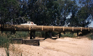
This bridge crosses a depression, hardly fair to call it a creek. The bridge is sans deck and these days there is no trace of it. It is on the Wensleydale line that left the Warrnambool Port Fairy line after Moriac and ambled down to near Wensleydale. The line was closed in 1948, this photo was taken on January 31, 1955, only 7 years after closure.


Photo by Des Jowett

Bridge over Jubilee Lake, Daylesford - North Creswick to Daylesford Line.

This bridge was unusual in that it had two decks, the upper deck for the train and the lower deck carrying pedestrians across Jubilee Lake in Daylesford. The North Creswick to Daylesford line was closed in July 1953. The following photos were taken in October 1955, not much more than two years after the closure of the line.

This bridge, albeit without its rail deck, is still in existence today, as the lower pedestrian bridge is still in use. 
Photo by Des Jowett

Looking across the deck back towards Daylesford. 

Photo by Des Jowett

Bridge over Latrobe River and Flats - Moe to Walhalla Narrow Gauge Railway.

No longer in existence and no trace can be found of this bridge. The path along which the long bridge crossed the river flats of the Latrobe River has been redeveloped as a sewage treatment plant, with the eastern boundary of one of the ponds closely aligned to the path of the bridge. The bridge consisted of 75 openings of 15 feet each, totalling approximately 1,125 feet.

The first photo is taken from the western side of the bridge, with the Latrobe River on the left and Moe township to the right.


Photo by Des jowett

Taken at the northern end of the bridge, with the river in the foreground, looking south towards Moe, the northern outskirts barely a mile away.

Photo by Des Jowett

Saturday, 9 January 2016

Road bridge over line at Triholm, Koo Wee Rup to Strzelecki Line

This bridge is famous for being in a derelict condition. The bridge carried the Main South Road over the Koo Wee Rup to Strzelecki Line at Triholm. Sadly, Triholm, as a township, has ceased to exist these days, it is now known as Poowong East. Triholm was originally settled in 1877 as a Danish village, as the first photo proclaims.


Someone in the area painted the side of a shed, which stands on the old ROW, roughly in the vicinity of the station, with a mural to remember the train.


Nothing remains of this bridge today, although the point where the line crossed the road is marked by a sign saying this was the alignment of the line.


This first photo of the bridge was taken at Easter 1940, from the western side of the bridge, or up side, looking east.


Photo by Wal Larsen
The second photo was taken in January 1965, by now the bridge is ruined and out of commission. The Main South Road has been shifted to the level on the eastern side of the bridge.


Photo by Des Jowett
The third photo was taken in 1986, the bridge has deteriorated slightly more. You can just see the Main South Road on the bottom right of the shot.


Photo by Darren Hodges
This photo is taken from the same vantage point as Darren's, but recently. The ROW can be seen curving away to the right to the Triholm station site. The earthen embankment on the right is still there, but the one on the left has been nibbled away.


This is the remains of the embankment that carried the Main South Road up to the bridge, the shot is just to the left of the previous shot.


And a view looking in the down direction from the opposite side of the road, the slight ROW embankment is right under the two cattle.


After this point, the line curved around and crossed Waterfall Road by a bridge, ran along the side of a hill, then crossed Waterfall Road again, and also the Lang Lang River at the same time. It then ran into relatively inaccessible country on the final section up to Strezelecki, crossing Waterfall Creek via a very nice wooden bridge.

It is unusual that not one atom of bridge remains today along the entire length of this line, every one has been completely erased from the landscape.

Tuesday, 5 January 2016

Bridge on Maldon to Laanecoorie Line

This bridge was at local mileage 10 miles 73ch and there was another large bridge at 10m 52ch with seven openings. These bridges never came into use, as the line beyond Shelbourne was not completed and the track was subsequently removed in 1897.

I am endebted to Des Jowett for providing these photos and also the background history.


Photo by Des Jowett

Photo by Des Jowett
This is thought to be the same bridge, taken in 1980 by Allan Renshaw, showing the bridge burnt out.

Photo by Allan Renshaw, from a collection held by Darren Hodges.
These two photos are thought to show the bridge at 10m 52ch. possibly during or shortly after construction.

Darren Hodges Collection

Darren Hodges Collection

Small Bridge on Maldon to Laanecoorie Line

This bridge was 19 chains past the Shelbourne station on the section of line intended to continue to Laanecoorie. 


This line was unusual in that the contractor had to be aware that the line may not be completed to it's authorised length and his contract price would be adjusted accordingly. Work stopped at about 1.5  miles beyond Shelbourne and they made Shelbourne the permanent terminus. Rails were laid to 9m 78ch, just a short distance past this bridge, and dismantled in December 1897. 

I am indebted to Des Jowett for the photos and background history of this line.
Photo by Des Jowett.

Bridge over Bradford Creek - Maldon to Laanecoorie Line

These two shots are provided by Des Jowett, showing the burnt out remains of the bridge over Bradford Creek on the Maldon to Laanecoorie Line.

I am indebted to Des Jowett for the photos and background history of this line.
Photo by Des Jowett

Photo by Des Jowett

Sunday, 20 December 2015

Identification of Bridges

I have recently received a huge list of GPS locations from Des Jowett, well known retired Railwayman. Des has spent a lot of time poring over the Google maps to spot the bridges and pin down their location for me. 

This has set a big target for me to go out and photograph the bridges that have been identified, and I am extremely grateful to Des for taking the time to do this work.

Des has also passed on a number of photos from his collection, covering bridges I have visited, and I will be adding them to the original posts.

Well done Des, and Thank You again!

Monday, 7 December 2015

Wimmera River Bridge at Quantong - Horsham to Carpolac Line.

Alongside the Wimmera Highway where it crosses the Wimmera River at Quantong, this bridge is in fairly good condition. It is of approximately 138 Metres in length, all wooden construction over a large and fairly full river.

Robert Redman advises that the nearby bridges over the river flats were dismantled by the Victorian Goldfields Railway, with the blessing of Victrack, in order to provide timbers for the repair of a bridge on their line near Castlemaine.


Yet timbers on the bridge indicate that sections were replaced in 1984, not long before the line closed in late 1986. There was a proposal in the early 80's to relay the line with heavier rail as far as East Natimuk so bigger diesels could haul GJX type hopper wagons to service the large grain facility at East Natimuk, and this could explain the repairs.


An oldie but goodie from Des Jowett, showing J503 on an Up Goroke to Horsham goods on January 6th. 1962. It is shown crossing Natimuk Creek just west of the town of Natimuk.
Photo by Des Jowett
This photo shows D3 641 approaching the Wimmera River bridge on 11-11-1957 with the weekly Balmoral to Horsham goods. It was very rare to get a D3 on this train which normally was a J, K or N.
Photo by Des Jowett

Video Clip

This clip is best viewed in full screen and high definition 1080p.


This time Ian captured a takeoff with the Phantom in slo-mo at 1/10 speed.


Glenelg River at Kanagulk, Hamilton to East Natimuk Line

The bridge is located on the property of the historic Fulham Homestead. We visited the homestead to ask permission to shoot the bridge and met Greg Walcott, the owner. Greg was very accommodating and gave us a brief tour of the restored cook house on the property. 

Most of the buildings on the property, including the homestead itself, are built from rock hewn from local outcrops, and Greg and his wife had restored the old cook house to original condition, and they now use it for entertaining. The roofs of many building were thatch, that was later covered by shingles and then roofing iron. The property dates back to 1848, so it predates the railways in Victoria by 6 years. 

Greg told us that some time ago a work team turned up at the property with the intention of demolishing the bridge, but he refused permission and obtained a heritage order on it. Fortunate indeed, as we would not have had anything to shoot. 

Originally there were two bridges at this crossing of the Glenelg River, but the southern bridge was burnt out. This leaves the existing bridge, which at a length of 189 Metres, is the second longest surviving wooden bridge in the state. The bridge is of all-wooden construction using 20 foot spans of timber beams.

The bridge is surrounded by River Red Gum, making it difficult to shoot with the drone, and even from the air, is still hidden to a large degree from view. It is in fair condition, like other bridges that are isolated on private property, this protects them to some degree.

All phots are taken from the northern end of the bridge, as it was not practical to cross the water to get to the southern end.


The 31st. of 32 piers supporting the bridge


Video Clip

This clip is best viewed full screen and in high definition 1080p.

Just a little cameo in this by a BullAnt I picked up from the launch site. He crawls down the left side of the camera lens at about 1:35, he did this a few times in material that was cut out of the clip. I don't know if he made it home again, but one hopes.


Thursday, 3 December 2015

Wannon River Bridge at Cavendish, Hamilton to East Natimuk Line

This bridge is relatively new in comparison to bridges in the Western District, having been built in 1917. Originally there were two branches, one from East Natimuk to Toolondo, and the other from Hamilton to Cavendish. The middle section was not completed until 1917.

This is a composite bridge, with 3 main spans of 12.8 Metres in steel plate girders and 7 sections of 20 foot wooden beams. The total length of the bridge is 75 Metres.

Sadly, the bridge is not in good condition, although some attempts appear to have been made to encase some of the piles in concrete caisons. It is considered a local attraction and visitors are encouraged to visit the bridge. One pier has recently rotted away to the point where the pier has collapsed into the water at the southern end. None of the wooden spans are left intact.

We met the friendly owners of the Bridge Cafe, adjacent to the bridge, Nick and Vicki, who supplied us with refreshments on a very warm early December day. If you pass through, call in and see them. 


The collapsed pier at the southern end of the bridge.


This photo comes from Des Jowett. He was working J503 on a Hamilton to Horsham goods. The photo is taken from the north east corner of the bridge. Des wrote:


"I always carried a camera at work on steam shifts and the one at Cavendish is the 8am Hamilton to Horsham goods. The loco is being worked "one man" until I was picked up after taking the photo then we continued on to Horsham"

Photo courtesy of Des Jowett

Video Clip

This clip is best viewed full screen and in high definition 1080p.


Wannon River Bridge at Casterton

This bridge is significant in that it is the longest surviving timber bridge in Victoria, at 293 Metres. It was built during the construction of the Branxholme to Casterton line in 1884, and has survived largely intact due mainly to the fact that it does not threaten anybody and is isolated out in the middle of grazing lands. 

In contrast, the nearby, and longer, bridge that carried the railway over the Glenelg River flats and the river itself, was demolished due to the risk to town folk from bits falling off it. This bridge was longer, estimated to be between 390 and 400 Metres long.

Sections of the bridge are sagging, but the tall section of the bridge over the Wannon River has survived many floods, with evidence of debris trapped by the bridge piles. The bridge is entirely made of wood, consisting of 64 openings of 15 feet. The maximum height of the tall section over the river is 9.1 Metres, while the section across the flood plain is mostly under 3 metres.

We were very fortunate to be able to locate the farm owner who gave permission to access a gate on the ROW and drive right up to the western bridge abutment.


This photo is surprising in that it appears to show a crosshead that was replaced in October of 2004. 


The Mortal enemy of bridges is flood debris, here there is a collection trapped by the bridge piles. The Wannon River can get quite full during the winter and this debris is a real risk to the bridge.


Video Clip

This is best viewed in full screen and high definition 1080p.


This is a short clip taken by my friend Ian with his iPhone 5 in slo-mo showing the Phantom landing.