Visit Map

Wednesday 6 April 2022

8 Bridges across the Sandy Creek arm of the Lake Hume - Wodonga to Cudgewa Railway

These are a series of wooden bridges, interspersed with embankments on the original alignment of the Wodonga to Cudgewa Railway. The bridges were abandoned in the 1950s when a new, steel span bridge was constructed further south, after the Hume Dam was raised to hold more water.

That newer bridge was deconstructed in later years after the line was closed and the ROW converted into a rail trail. The steel spans were removed and stored beside the old line at Bandiana, some spans went to the Yarrawonga to Mulwala line, some to Dartmoor in South Western Victoria where they are stored pending re-use, and some to repair the Avon River Bridge in Gippsland. The remaining 13 spans are still at Bandiana. The spans that went to the Avon River were not required, as the entire bridge was replaced in the early 2020s.

From time to time, as the water level in Lake Hume gets low, the eight bridge remains become visible. Brad Mull shot a really good flyover of the remains some time ago during a low water period. I am indebted to Brad for the use of this footage, it is shown below.  


And back again in the reverse direction:


Monday 21 March 2022

South Gippsland Railway Line - Great Southern Rail Trail - Koonwarra Bridges.

 Back on Sunday, June 14, 2015, almost 7 years ago, I came down to Koonwarra to photograph and document the series of bridges on this section of the South Gippsland Railway line. And on June 18, 2019, in a comment I announced my intention to come back with my drone and fly this section.

Well, I finally got to come back, not with the drone, but with a hand-held GoPro while riding an electric mountain bike. Actually, the GoPro is the fourth one I have owned, and is the latest Hero10 Black, a very impressive performer. It features Hypersmooth 4.0 in-body video stabilisation, which does an excellent job of smoothing out any vibrations when you are hand-holding it. The stabilisation is so good it removes the need for a gimbal system, but I found it is a bit tricky to keep it level, so my horizon was a bit askew. More practice is required.

In the 7 years since I was last here, a lot has changed at Koonwarra. The rail trail has been finished over the old bridges, keeping most of the original trestle supports intact, with a new deck of concrete paving and safety fencing. But the biggest change is the new highway deviation that takes the South Gippsland Highway over the top of the rail trail to the north, then back again a little later to eliminate a series of curves in the original highway alignment. 

Since the railway preservation group that were running trains on the line from Nyora to Leongatha wound up, the ROW has very quickly been converted into a rail trail, and it is well worth a ride along it. It is a very well constructed trail, with fabulous views. Along the section here, there are notice boards providing historical notes and photos of the wooden bridges when they were in use for trains.

The video clip starts close to the Koonwarra Recreation Reserve and travels over the group of three bridges, then turns around and heads back on the trail to where it started.


Sunday 9 January 2022

Derelict road bridge that carried Snowgum Road over Mount Misery Creek in Dereel, Western Victoria

 This photograph was contributed by Deon. I have not seen these bridge remains personally, but it appears this is the remains of a wooden road bridge. It was constructed in 1906 to provide permanent access to the township of Berringa and to facilitate the transportation of gold extracted from the Berringa goldfields. Its official name is the Mount Misery Creek Bridge.


Photo courtesy of Deon.


Wannon River bridge at Wannon - Hamilton to Coleraine Railway.

This is another of those hidden gems that was revealed by a careful poring over Google Maps. I missed photographing this bridge when I made the trip to Casteron in December of 2015, although I had speculated that it existed before then. It was not easy to find, as the imagery was not good at the time.

While the imagery is still quite indistinct, the fact that the railway crossed the Wannon River was a strong clue. This time around, I took the opportunity to travel on to Wannon.

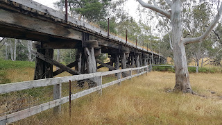
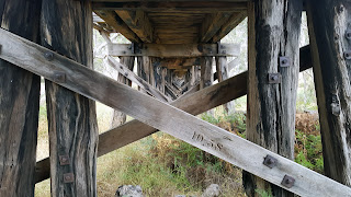
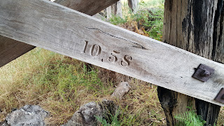
The bridge is a good 100 metres long and is in relatively good condition, although it is not advisable to walk over it as sections of the deck are rotten. Newish cross braces on the bridge indicate that it received repairs in September/October of 1958, as shown in the photos. 

On the lead-up to the bridge, the track ballast seems to consist predominantly of crushed volcanic rock, rather than the usual granititic rock. 

The bridge can be accessed by driving north up the Wannon - Nigretta Falls Road from the B160 Glenelg Highway. A short distance up the road, as it gently curves right, the bridge can just be seen straight ahead, about 100 Metres from the road. If you wish to walk to it, you should consider that I encountered two snakes along the ROW. If you keep driving past the curve for about half a kilometre, you will see where the ROW crossed the road, and this is the best place to start from, walking back to the west along the ROW.

I walked to the bridge, only to find that the battery in my camera was flat, so had to go back to the car. I then discovered that the spare battery was also flat. I am normally better at keeping batteries charged than this, and so I paid the price of being on-site wthout a camera. I then remembered that I had my phone on me, and that saved the day.

Not wanting to meet up with the snakes again, my second trip from the car to the bridge was done through the farmer's paddock on the north side. For safety reasons, I always wear heavy, long rubber boots when out in the bush. 


Eastern approach to the bridge, photographed on the northern side.


Wide shot showing the whole bridge.


The collapsed section in the second span from the eastern abuttment.


View along the bridge on the north side.


Through span view.


View closer to the middle section over the river, from the south side. The bridge is quite tall in the middle over the (dry as a bone) Wannon River.


Marking indicating that this brace was replaced in October of 1958.