Visit Map

Tuesday 21 December 2021

Bridge over flood opening, near Healesville - Kinglake Road - Lilydale to Healesville Line.

 Finally catching up on three bridges I did not have time to view in September of 2018. This is simply a wooden bridge over a flood opening near the Healesville - Kinglake Road. It has 5 openings, probably 10 foot (I did not measure them), and a longitudinal wooden deck. It simply serves to provide drainage access to any potential floodwaters from the Watts River, about 100 metres further down the line to the east. 


Bridge over Watts River, Healesville - Lilydale to Healesville Line.

Consisting of 15 openings, each of 11 foot, with a central 15 foot span, this bridge is 168 feet long, or 51.2 Metres. The bridge has steel spans with a transverse wooden deck. The bridge is in very good condition, and is easily visited, as it is only a short walk down the line from the road crossing on the Healesville - Kinglake Road. It is also possible to get to it, with a shorter path, from inside the Healesville Racecourse, being adjacent to the horse stables.


View along the bridge, looking east.


Side view, again looking east. 


View of central spans over the Watts River.


Bridge over creek in Healesville - Lilydale to Healesville Line

 This is a small wooden bridge over a drain/creek, just to the west of the Healesville Racecourse. It is 5 spans, and is in good condition. Interesting, in that the 3 wooden bridges in the Healesville township all escaped the 'modernisation' that was inflicted on other bridges along the line. 


Side view of bridge, looking east.


View along the bridge, looking east, with the Donovans Road road-over-rail bridge just visible in the distance. Donovans road is covered here: https://abandonedbutnotforgotten1.blogspot.com/2018/09/bridge-over-lilydale-to-healesville.html


Wednesday 1 December 2021

Mount Evelyn Railway Station in December 1961 & January 1962

 Historical photos of Mount Evelyn in December of 1961 and January 1962, taken by Michael Brudar. These photos are used by permission of Michael, as I may appear in one or two from time to time. In point of fact, I was a bugger of a photo-bomber, popping up when not expected.

Michael and I haunted this station and surrounding districts, as we were not yet able to drive or ride a motorcycle. But we did very soon after. We used to ride the goods trains and travel up to Yarra Junction and Warburton with our bicycles in the Z van. 

Michael had a very nice 35mm camera, used to take these shots. I did not have a camera at the time, so I used to amuse myself by getting in shots where I was not wanted. 

If you would like to see more of Michaels photography, see his Flikr Page Sadly, Michael passed away a couple of years back. Knowing he only had a certain amount of time, Michael set about scanning his photo collection and putting it up on Flikr.


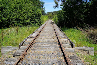
Mount Evelyn Station viewed from the West end, looking East, in December of 1961.


A Down goods headed up by K188, which was stationed at Lilydale for a long period of time. Michael and I were about to climb on this goods for the trip to Warburton. The Station House can just be seen behind the wagons.


Michael has this photo placed at Mount Evelyn, however I believe it is actually Seville, as it is not on a curve like Mount Evelyn. I can be seen, with my back to the camera, seated on a luggage trolley. I was chatting to the Engine Driver. 


Bridge over Bailey Road and Stringybark Creek, Wandin. Lilydale to Warburton Railway

 This bridge probably sets the standard for bridges on this line. The Lilydale to Warburton Railway was constructed in 1901, and, as such, is a relatively late addition to the Victorian Railways Network. The Lilydale to Healesville Railway had been opened in stages, with the first section to Yarra Glen opened in May of 1888. 

There does not seem to be any evidence that I can find, of timber being used for bridge construction, with the sole exception being the road over rail bridge near Woori Yallock. But that bridge only carries a road, not the railway. Perhaps wherever the rail line is carried over a bridge, the construction may have been brick or concrete piers with steel spans from the outset.

I would be interested to know if anyone has knowledge of the bridges being replaced in later years. I rode this line when traveling to Powelltown via Yarra Junction in the early 60s but I don't recall taking much notice of the bridges at the time.

Bailey Road is un-made and the area is very dusty. To the east of the span over the road is Stringybark Creek. The bridge is quite tall, approximately 4 meters to the bottom of the steel span.


View taken from the North side of the bridge, looking South. Stringybark Creek is under the left span.


The bridge deck, looking to the East. The young lady holding the horse at the far end had, quite wisely, dismounted and walked the horse across when no-one else was on the bridge.


Bridge over Little Yarra River, near Britannia Creek Sidings, Lilydale to Warburton Railway

Similar in construction to all other bridges on this line, concrete piers with steel spans. At the time of taking the photo, the river was flowing quite full, with substantial rains in previous days.


Side view. The blacks in this shot have been slightly enhanced to show the detail under the bridge.


This is the second bridge in the vicinity of the Little Yarra River, but was dry at the time of taking the photo.


Side view, blacks slightly enhanced to see support detail.