Visit Map

Sunday 17 January 2016

Jeparit - Yanac Branch - Bridge over Wimmera River at Jeparit.

The bridge is still in existence over the Wimmera River, although the aerial view appears to show it without decking. It is to the west of the township of Jeparit, crossing the Wimmera River a short distance before the river empties into Lake Hindmarsh. I have this bridge marked for a visit to photograph it, having missed out on the opportunity when shooting the bridge at Quantong. 

However I have some photos from Allan Renshaw showing an ARHS special pulled by J 508 crossing the bridge in September 1966.

Photo by Allan Renshaw. From the collection of Darren Hodges

Monday 11 January 2016

Bridge over Howard's Creek - Navarre Line

This bridge on the Navarre line that branched off the Ararat to Avoca line between Dunneworthy and Eversley. The line's ROW is now the Tulkara Railway Road, and the bridge has been replaced with a concrete culvert bridge. 

These two photos were taken in December of 1962.

Photo by Des Jowett


Photo by Des Jowett 

Bridge over creek on the Wensleydale Line.

This bridge crosses a depression, hardly fair to call it a creek. The bridge is sans deck and these days there is no trace of it. It is on the Wensleydale line that left the Warrnambool Port Fairy line after Moriac and ambled down to near Wensleydale. The line was closed in 1948, this photo was taken on January 31, 1955, only 7 years after closure.


Photo by Des Jowett

Bridge over Jubilee Lake, Daylesford - North Creswick to Daylesford Line.

This bridge was unusual in that it had two decks, the upper deck for the train and the lower deck carrying pedestrians across Jubilee Lake in Daylesford. The North Creswick to Daylesford line was closed in July 1953. The following photos were taken in October 1955, not much more than two years after the closure of the line.

This bridge, albeit without its rail deck, is still in existence today, as the lower pedestrian bridge is still in use. 
Photo by Des Jowett

Looking across the deck back towards Daylesford. 

Photo by Des Jowett

Bridge over Latrobe River and Flats - Moe to Walhalla Narrow Gauge Railway.

No longer in existence and no trace can be found of this bridge. The path along which the long bridge crossed the river flats of the Latrobe River has been redeveloped as a sewage treatment plant, with the eastern boundary of one of the ponds closely aligned to the path of the bridge. The bridge consisted of 75 openings of 15 feet each, totalling approximately 1,125 feet.

The first photo is taken from the western side of the bridge, with the Latrobe River on the left and Moe township to the right.


Photo by Des jowett

Taken at the northern end of the bridge, with the river in the foreground, looking south towards Moe, the northern outskirts barely a mile away.

Photo by Des Jowett

Saturday 9 January 2016

Road bridge over line at Triholm, Koo Wee Rup to Strzelecki Line

This bridge is famous for being in a derelict condition. The bridge carried the Main South Road over the Koo Wee Rup to Strzelecki Line at Triholm. Sadly, Triholm, as a township, has ceased to exist these days, it is now known as Poowong East. Triholm was originally settled in 1877 as a Danish village, as the first photo proclaims.


Someone in the area painted the side of a shed, which stands on the old ROW, roughly in the vicinity of the station, with a mural to remember the train.


Nothing remains of this bridge today, although the point where the line crossed the road is marked by a sign saying this was the alignment of the line.


This first photo of the bridge was taken at Easter 1940, from the western side of the bridge, or up side, looking east.


Photo by Wal Larsen
The second photo was taken in January 1965, by now the bridge is ruined and out of commission. The Main South Road has been shifted to the level on the eastern side of the bridge.


Photo by Des Jowett
The third photo was taken in 1986, the bridge has deteriorated slightly more. You can just see the Main South Road on the bottom right of the shot.


Photo by Darren Hodges
This photo is taken from the same vantage point as Darren's, but recently. The ROW can be seen curving away to the right to the Triholm station site. The earthen embankment on the right is still there, but the one on the left has been nibbled away.


This is the remains of the embankment that carried the Main South Road up to the bridge, the shot is just to the left of the previous shot.


And a view looking in the down direction from the opposite side of the road, the slight ROW embankment is right under the two cattle.


After this point, the line curved around and crossed Waterfall Road by a bridge, ran along the side of a hill, then crossed Waterfall Road again, and also the Lang Lang River at the same time. It then ran into relatively inaccessible country on the final section up to Strezelecki, crossing Waterfall Creek via a very nice wooden bridge.

It is unusual that not one atom of bridge remains today along the entire length of this line, every one has been completely erased from the landscape.

Tuesday 5 January 2016

Bridge on Maldon to Laanecoorie Line

This bridge was at local mileage 10 miles 73ch and there was another large bridge at 10m 52ch with seven openings. These bridges never came into use, as the line beyond Shelbourne was not completed and the track was subsequently removed in 1897.

I am endebted to Des Jowett for providing these photos and also the background history.


Photo by Des Jowett

Photo by Des Jowett
This is thought to be the same bridge, taken in 1980 by Allan Renshaw, showing the bridge burnt out.

Photo by Allan Renshaw, from a collection held by Darren Hodges.
These two photos are thought to show the bridge at 10m 52ch. possibly during or shortly after construction.

Darren Hodges Collection

Darren Hodges Collection

Small Bridge on Maldon to Laanecoorie Line

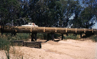
This bridge was 19 chains past the Shelbourne station on the section of line intended to continue to Laanecoorie. 


This line was unusual in that the contractor had to be aware that the line may not be completed to it's authorised length and his contract price would be adjusted accordingly. Work stopped at about 1.5  miles beyond Shelbourne and they made Shelbourne the permanent terminus. Rails were laid to 9m 78ch, just a short distance past this bridge, and dismantled in December 1897. 

I am indebted to Des Jowett for the photos and background history of this line.
Photo by Des Jowett.

Bridge over Bradford Creek - Maldon to Laanecoorie Line

These two shots are provided by Des Jowett, showing the burnt out remains of the bridge over Bradford Creek on the Maldon to Laanecoorie Line.

I am indebted to Des Jowett for the photos and background history of this line.
Photo by Des Jowett

Photo by Des Jowett