Visit Map

Wednesday 6 April 2022

8 Bridges across the Sandy Creek arm of the Lake Hume - Wodonga to Cudgewa Railway

These are a series of wooden bridges, interspersed with embankments on the original alignment of the Wodonga to Cudgewa Railway. The bridges were abandoned in the 1950s when a new, steel span bridge was constructed further south, after the Hume Dam was raised to hold more water.

That newer bridge was deconstructed in later years after the line was closed and the ROW converted into a rail trail. The steel spans were removed and stored beside the old line at Bandiana, some spans went to the Yarrawonga to Mulwala line, some to Dartmoor in South Western Victoria where they are stored pending re-use, and some to repair the Avon River Bridge in Gippsland. The remaining 13 spans are still at Bandiana. The spans that went to the Avon River were not required, as the entire bridge was replaced in the early 2020s.

From time to time, as the water level in Lake Hume gets low, the eight bridge remains become visible. Brad Mull shot a really good flyover of the remains some time ago during a low water period. I am indebted to Brad for the use of this footage, it is shown below.  


And back again in the reverse direction:


Monday 21 March 2022

South Gippsland Railway Line - Great Southern Rail Trail - Koonwarra Bridges.

 Back on Sunday, June 14, 2015, almost 7 years ago, I came down to Koonwarra to photograph and document the series of bridges on this section of the South Gippsland Railway line. And on June 18, 2019, in a comment I announced my intention to come back with my drone and fly this section.

Well, I finally got to come back, not with the drone, but with a hand-held GoPro while riding an electric mountain bike. Actually, the GoPro is the fourth one I have owned, and is the latest Hero10 Black, a very impressive performer. It features Hypersmooth 4.0 in-body video stabilisation, which does an excellent job of smoothing out any vibrations when you are hand-holding it. The stabilisation is so good it removes the need for a gimbal system, but I found it is a bit tricky to keep it level, so my horizon was a bit askew. More practice is required.

In the 7 years since I was last here, a lot has changed at Koonwarra. The rail trail has been finished over the old bridges, keeping most of the original trestle supports intact, with a new deck of concrete paving and safety fencing. But the biggest change is the new highway deviation that takes the South Gippsland Highway over the top of the rail trail to the north, then back again a little later to eliminate a series of curves in the original highway alignment. 

Since the railway preservation group that were running trains on the line from Nyora to Leongatha wound up, the ROW has very quickly been converted into a rail trail, and it is well worth a ride along it. It is a very well constructed trail, with fabulous views. Along the section here, there are notice boards providing historical notes and photos of the wooden bridges when they were in use for trains.

The video clip starts close to the Koonwarra Recreation Reserve and travels over the group of three bridges, then turns around and heads back on the trail to where it started.


Sunday 9 January 2022

Derelict road bridge that carried Snowgum Road over Mount Misery Creek in Dereel, Western Victoria

 This photograph was contributed by Deon. I have not seen these bridge remains personally, but it appears this is the remains of a wooden road bridge. It was constructed in 1906 to provide permanent access to the township of Berringa and to facilitate the transportation of gold extracted from the Berringa goldfields. Its official name is the Mount Misery Creek Bridge.


Photo courtesy of Deon.


Wannon River bridge at Wannon - Hamilton to Coleraine Railway.

This is another of those hidden gems that was revealed by a careful poring over Google Maps. I missed photographing this bridge when I made the trip to Casteron in December of 2015, although I had speculated that it existed before then. It was not easy to find, as the imagery was not good at the time.

While the imagery is still quite indistinct, the fact that the railway crossed the Wannon River was a strong clue. This time around, I took the opportunity to travel on to Wannon.

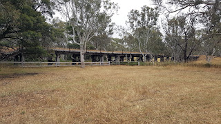
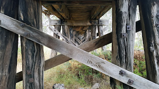
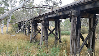
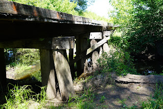
The bridge is a good 100 metres long and is in relatively good condition, although it is not advisable to walk over it as sections of the deck are rotten. Newish cross braces on the bridge indicate that it received repairs in September/October of 1958, as shown in the photos. 

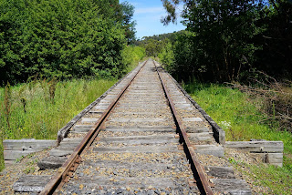
On the lead-up to the bridge, the track ballast seems to consist predominantly of crushed volcanic rock, rather than the usual granititic rock. 

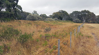
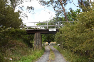
The bridge can be accessed by driving north up the Wannon - Nigretta Falls Road from the B160 Glenelg Highway. A short distance up the road, as it gently curves right, the bridge can just be seen straight ahead, about 100 Metres from the road. If you wish to walk to it, you should consider that I encountered two snakes along the ROW. If you keep driving past the curve for about half a kilometre, you will see where the ROW crossed the road, and this is the best place to start from, walking back to the west along the ROW.

I walked to the bridge, only to find that the battery in my camera was flat, so had to go back to the car. I then discovered that the spare battery was also flat. I am normally better at keeping batteries charged than this, and so I paid the price of being on-site wthout a camera. I then remembered that I had my phone on me, and that saved the day.

Not wanting to meet up with the snakes again, my second trip from the car to the bridge was done through the farmer's paddock on the north side. For safety reasons, I always wear heavy, long rubber boots when out in the bush. 


Eastern approach to the bridge, photographed on the northern side.


Wide shot showing the whole bridge.


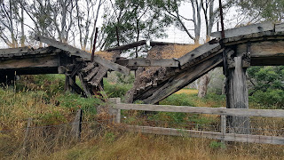
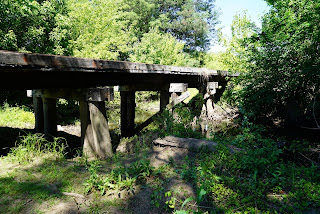
The collapsed section in the second span from the eastern abuttment.


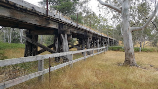
View along the bridge on the north side.


Through span view.


View closer to the middle section over the river, from the south side. The bridge is quite tall in the middle over the (dry as a bone) Wannon River.


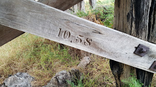
Marking indicating that this brace was replaced in October of 1958.


Tuesday 21 December 2021

Bridge over flood opening, near Healesville - Kinglake Road - Lilydale to Healesville Line.

 Finally catching up on three bridges I did not have time to view in September of 2018. This is simply a wooden bridge over a flood opening near the Healesville - Kinglake Road. It has 5 openings, probably 10 foot (I did not measure them), and a longitudinal wooden deck. It simply serves to provide drainage access to any potential floodwaters from the Watts River, about 100 metres further down the line to the east. 


Bridge over Watts River, Healesville - Lilydale to Healesville Line.

Consisting of 15 openings, each of 11 foot, with a central 15 foot span, this bridge is 168 feet long, or 51.2 Metres. The bridge has steel spans with a transverse wooden deck. The bridge is in very good condition, and is easily visited, as it is only a short walk down the line from the road crossing on the Healesville - Kinglake Road. It is also possible to get to it, with a shorter path, from inside the Healesville Racecourse, being adjacent to the horse stables.


View along the bridge, looking east.


Side view, again looking east. 


View of central spans over the Watts River.


Bridge over creek in Healesville - Lilydale to Healesville Line

 This is a small wooden bridge over a drain/creek, just to the west of the Healesville Racecourse. It is 5 spans, and is in good condition. Interesting, in that the 3 wooden bridges in the Healesville township all escaped the 'modernisation' that was inflicted on other bridges along the line. 


Side view of bridge, looking east.


View along the bridge, looking east, with the Donovans Road road-over-rail bridge just visible in the distance. Donovans road is covered here: https://abandonedbutnotforgotten1.blogspot.com/2018/09/bridge-over-lilydale-to-healesville.html


Wednesday 1 December 2021

Mount Evelyn Railway Station in December 1961 & January 1962

 Historical photos of Mount Evelyn in December of 1961 and January 1962, taken by Michael Brudar. These photos are used by permission of Michael, as I may appear in one or two from time to time. In point of fact, I was a bugger of a photo-bomber, popping up when not expected.

Michael and I haunted this station and surrounding districts, as we were not yet able to drive or ride a motorcycle. But we did very soon after. We used to ride the goods trains and travel up to Yarra Junction and Warburton with our bicycles in the Z van. 

Michael had a very nice 35mm camera, used to take these shots. I did not have a camera at the time, so I used to amuse myself by getting in shots where I was not wanted. 

If you would like to see more of Michaels photography, see his Flikr Page Sadly, Michael passed away a couple of years back. Knowing he only had a certain amount of time, Michael set about scanning his photo collection and putting it up on Flikr.


Mount Evelyn Station viewed from the West end, looking East, in December of 1961.


A Down goods headed up by K188, which was stationed at Lilydale for a long period of time. Michael and I were about to climb on this goods for the trip to Warburton. The Station House can just be seen behind the wagons.


Michael has this photo placed at Mount Evelyn, however I believe it is actually Seville, as it is not on a curve like Mount Evelyn. I can be seen, with my back to the camera, seated on a luggage trolley. I was chatting to the Engine Driver. 


Bridge over Bailey Road and Stringybark Creek, Wandin. Lilydale to Warburton Railway

 This bridge probably sets the standard for bridges on this line. The Lilydale to Warburton Railway was constructed in 1901, and, as such, is a relatively late addition to the Victorian Railways Network. The Lilydale to Healesville Railway had been opened in stages, with the first section to Yarra Glen opened in May of 1888. 

There does not seem to be any evidence that I can find, of timber being used for bridge construction, with the sole exception being the road over rail bridge near Woori Yallock. But that bridge only carries a road, not the railway. Perhaps wherever the rail line is carried over a bridge, the construction may have been brick or concrete piers with steel spans from the outset.

I would be interested to know if anyone has knowledge of the bridges being replaced in later years. I rode this line when traveling to Powelltown via Yarra Junction in the early 60s but I don't recall taking much notice of the bridges at the time.

Bailey Road is un-made and the area is very dusty. To the east of the span over the road is Stringybark Creek. The bridge is quite tall, approximately 4 meters to the bottom of the steel span.


View taken from the North side of the bridge, looking South. Stringybark Creek is under the left span.


The bridge deck, looking to the East. The young lady holding the horse at the far end had, quite wisely, dismounted and walked the horse across when no-one else was on the bridge.


Bridge over Little Yarra River, near Britannia Creek Sidings, Lilydale to Warburton Railway

Similar in construction to all other bridges on this line, concrete piers with steel spans. At the time of taking the photo, the river was flowing quite full, with substantial rains in previous days.


Side view. The blacks in this shot have been slightly enhanced to show the detail under the bridge.


This is the second bridge in the vicinity of the Little Yarra River, but was dry at the time of taking the photo.


Side view, blacks slightly enhanced to see support detail.


Wednesday 24 November 2021

Bridge over flood plain, Britannia Sidings, East of Yarra Junction. Lilydale to Warburton Railway

 This bridge differs from others I looked at on this line in that the piers are constructed of brick rather than poured concrete. Otherwise, it is an unremarkable bridge consisting of 9 brick piers with steel beams and the usual wooden deck used on rail trails. It is approximately 48 Metres long.


View of North side of the bridge, looking East towards Warburton.


An interesting little historical brief, laminated and attached to a post on the approach to the bridge. It gives a little historical background to Britannia Sidings and the private railway that fed goods to the main line.


Cattle Underpass near Woori Yallock Creek. Lilydale to Warburton Railway.

Built using the same recipe as all the other bridges along this line, this consists of four concrete piers and steel beams. 

It is just short of the larger Woori Yallock Creek bridge.


Bridge over Woori Yallock Creek, Woori Yallock. Lilydale to Warburton line.

 A low bridge of steel beams over concrete piers, across the Woori Yallock Creek and it's large surrounding wetlands. It is very likely that this bridge is original, and simply re-decked to make it suitable for a rail trail. It is approximately 176 Metres long, with a second section of 55 Metres. 


An oblique view , North side of bridge, looking East towards Warburton.


The main part of the Woori Yallock Creek, rather full and free flowing. View from South side of bridge, looking East towards Warburton.


Complimentary view from the North side of the creek.


Monday 22 November 2021

Road over Rail Bridge, Private Access road at Woori Yallock, Lilydale to Warburton Railway

 This bridge appears to be pretty original. It has steel I beam spans spans on wooden trestles and does not appear to have been 'gentrified' for the conversion of the ROW to a rail trail. It is protected from stock crossing at either end by cattle grids. On the other hand, it may have been modified from wooden spans to steel spans at an earlier time. 


View looking towards Warburton.


View of underside detail.


Rail over Road Bridge, Kylie Lane, Seville East. Lilydale to Warburton Railway

Finally out of lockdown and out on the trails again. This time being the first outing for the new bicycle. I had bought a folding mountain bike to ride the trails, but after my cardiac surgery, I found it stressful riding any distance. So I bought a conversion kit and converted the bike into an e-Bike. 

I drove to the car park at the old Woori Yallock station, then rode back towards the west to access this bridge, and others along the Warburton Rail Trail.

This bridge is pretty unremarkable, being steel beams on concrete piers, with 3 openings. Pretty much all of the bridges on the old Lilydale to Warburton line are of similar construction. This bridge allows Kylie Lane to pass under the rail line. I called out to Kylie, but she did not answer, must have been off enjoying the lovely Spring weather :-)


Looking along the rail trail towards Warburton.


View of Kylie Lane on the North side of the bridge.


It was too steep to get down to the roadway, so this view is the best I could manage from the ROW.


Fortunately, Deon drove along Kylie Lane and sent me this photo showing the bridge from gound level. Thank you Deon.


Friday 22 October 2021

Bridge over Percival Creek south of Pyalong - Heathcote Junction to Bendigo Line.

Hooray, finally able to break out of the COVID restrictions, and get on the road again. It has been so long, I forgot how to perform some of the trickier drone maneuvers and also the editing of this blog.

But finally able to go out with the express purpose of investigating this very interesting bridge.  I found this bridge originally using Google Earth, by speculating that there should be a bridge  at this location, even though the aerial view did not clearly show one there. The fact that there was a creek here pointed to the possibility of a bridge, but it could not be seen.

By using Google Earth instead of the normal Google Maps view, there is a history tool that allows you to rewind the date of the aerial views, and when I wound it back, lo and behold, there was the bridge. As it turns out, a long held friend of mine, John, moved to Pyalong earlier this year, and I was able to get him to affirm the presence of the bridge.

The bridge is quite substantial, it is an estimated 85 Metres long with 19 openings, and is actually in better condition than the better-known bridge over Mollison's Creek, in town. The date on the timbers at the north end suggest that the last maintenance work was carried out in 1949. Like all abandoned wooden bridges, the deck timbers have rotted through in a about 3 places (at time of examination) and there are prominent signs posted warning people not to walk under the structure, plus wire barriers at the abutments to try and keep people off the deck. Otherwise, the bridge is more or less intact.

The people on the adjacent property on the west side claim that they lease the land that the bridge is on, and are a bit sensitive about people wandering onto the site. We found a convenient parking spot on the highway within about 100 Metres of the bridge, just next to an 'Overtaking Lane 400M' sign. 

The following photos are taken at the north end of the bridge on the west side, looking back towards Heathcote Junction.


Pyalong - Third bridge, dismantled - Heathcote Junction to Bendigo Line.


My friend John, who lives in Pyalong, had been told by the publican at the Pyalong Hotel, that originally there had been 3 timber bridges in the district, but I had only managed to locate 2 of them. Fortunately, John had found this one on his daily walk routine.

There is almost nothing left of the bridge, it had been extensively excavated, in fact the excavator is still beside the bridge.

This appears to be an example of where a bridge was filled in as an embankment, then later on the local farmer has dug it out again, exposing the bridge remains. This was presumably done to allow stock to move more easily from one side to the other.

According to the VR Grades book, this bridge was originally 6 openings of 15 foot, plus one opening of 20 feet.