Visit Map

Sunday 5 November 2017

Bridge over Diamond Creek at Eltham

In something of a break with tradition, I decided to cover this bridge even though it is on a fully operational line, and not abandoned. My reasoning is that the bridge is something of a dinosaur, being almost entirely wood in its construction and being used by high-frequency suburban trains. 

I figure it is only a matter of time before someone shrieks out in horror that 'the public is in great danger as long as Metro allows this ancient and unsafe bridge to be used'.

Of course those among us know that a properly maintained, and well constucted wooden bridge is perfectly adequate for the relatively light loads of suburban electric stock, but that probably won't stop a full-blown outbreak of ignorant hysteria. 

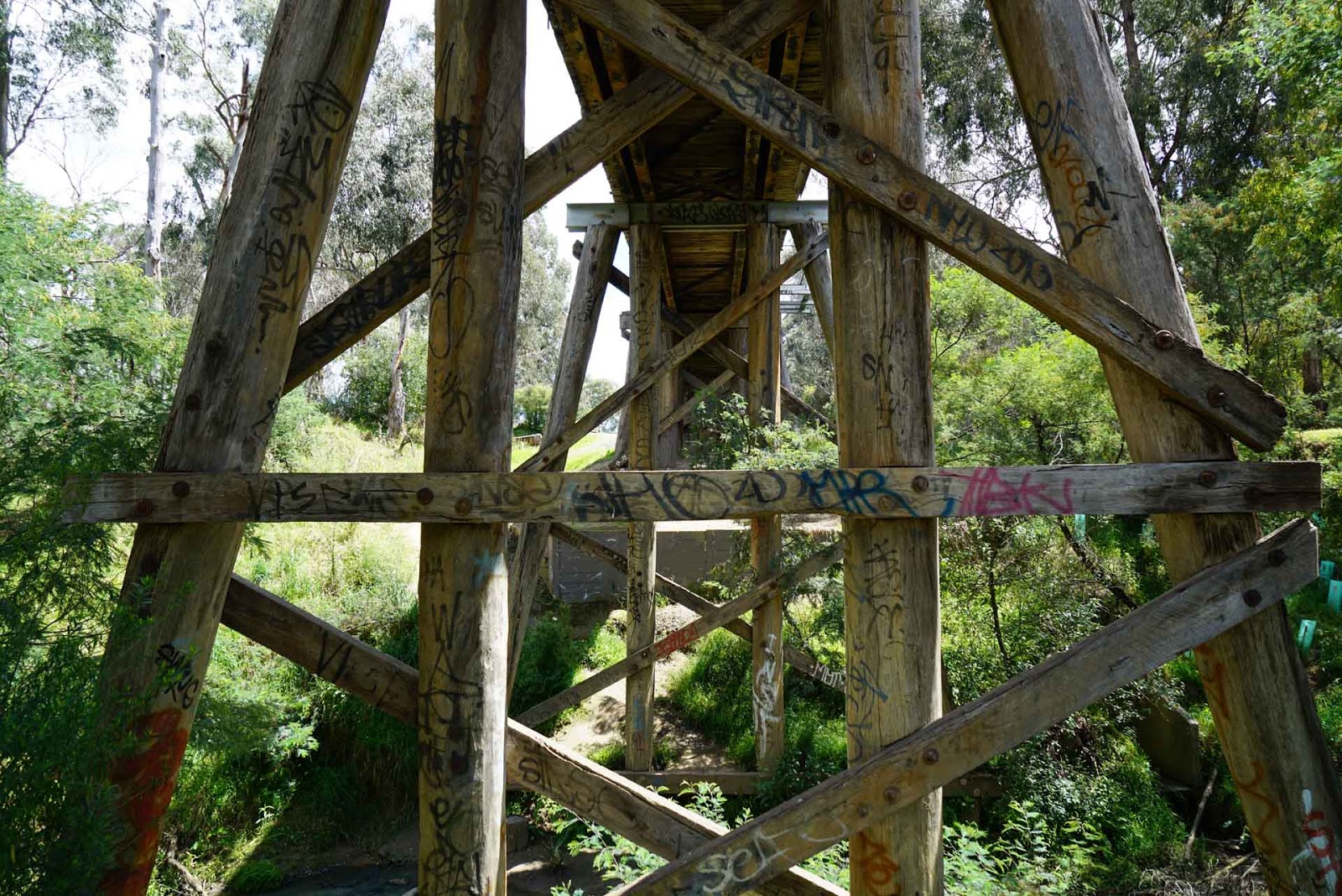
The bridge is entirely wooden for its full length of 195 Metres, except for two steel sections supporting the spans across Diamond Creek itself. There are 34 x 15 foot spans, plus 4 x 30 foot spans in the bridge. The remaining spans have wooden beams with transverse decking, and classic gravel beams with tie rods, wooden sleepers and ballasted rail. In several places, the piers have steel I beam crossheads, replacing the original wooden ones. 

The refuges are now all-steel construction with scaffold pipe style hand-rails along the full length of both sides.

I was able to get some aerial footage of the bridge, which was a little difficult due to the high number of potential drone snags. There are many trees close to the line, plus many cables and wires, such that is it not easy to get lower angle shots, therefore most of the footage is shot from an altitude that does not fully reveal the structure of the bridge. You may notice, in viewing the footage, that the aircraft comes perilously close to tree branches at times.


Shot from the North side of the bridge, nearest the sports oval. Showing the piers including the opening for the road into the sports ground. One span is devoted to each side of the road.

Looking back from the same spot as the previous photo, towards Diamond Creek.

Also in the same area, but underneath the bridge.

And a shot exposed to show the detail on the underneath of the bridge, showing the transverse decking. A slightly disturbing sight is one of the lock-nuts holding the railing bracket to the crosshead, in upper left, has unwound itself back to the start of the thread. Hello maintenance!!

Again the same area, now on the South side of the bridge.

View across Diamond Creek, unfortunately obscured by some errant scrub.

Again looking across the creek, underneath the bridge.

Reverse shot, from the walking track, back towards Eltham Station.

Closer to the station again, showing example of steel crossheads, just under the refuge.


Bridge crossing the access road to the sports ground. There is a sign on the bridge asking people to report any impact with the bridge to Metro.


Sunday 2 July 2017

Worth a Second Visit.....

There have been a number of locations I have visited in the past that I did not feel quite happy with. In particular, I thought they could do with an aerial view of the site, so I decided to go back to them and visit them again with the drone.

The first of these I chose was the Jumbunna Embankment on the Korumburra - Outrim Branch. I think the aerial view shows the scale of this construction better than the still shots could achieve.

Others sites will follow as I get time to re-visit them. Follow the link to the entry, then see the video clip at the bottom of the entry.

Sunday 9 April 2017

Bridge over Broken Creek, Number 1 - Nurmurkah to Picola Line

Sadly, on the way home from the last expedition to Barwon Downs, Timboon and Warrnambool, the old Falcon wagon began to give up its ghost. It had served me well, but was now labelled with that dreadful description "uneconomical to repair". It took me some time to save up the readies to replace it, and the (low) target was reached in late March, with almost the exact same car, but 8 years younger and white instead of silver.

A fortunate turn of events enabled me to get a new camera at the same time, a lovely Sony A7R Mark II, a full frame format mirrorless type with 42 Gigglepixies and a nice Zeiss zoom lens. 

So now armed with the new camera and a hopefully reliable car, I set off in early April to visit a long-time friend up at Tocumwal, with the aim of snaring him into helping me cover the bridges on the now-closed Numurkah to Picola line. 

The line was opened in two stages, from Numurkah to Nathalia in 1888, and Nathalia to Picola in 1896. The line is 20.5 miles long, and was eventually closed in December of 1986, so was only in operation for 90 years.

The first three identified bridges simply amounted to culverts over irrigation channels, so I elected not to visit them, but then there were 5 more substantial bridges, four of which continuously crossed Broken Creek. 

The first bridge over Broken Creek is at the 11.6 mile point, and I was rather surprised to find a well constructed bridge of steel spans supported by concrete piers and abutments, that would later turn out to be the same for all 5 bridges. This bridge is 75 Metres long.

Armed with the array of equipment, Ray and I set out to explore the first bridge and he was given the task of measuring the length with the wheeled measuring device. Roughly half way across the bridge, Ray decided to enter into an enterprise bargaining meeting over wages and conditions. I told him that there were no wages, and the only condition was that if he properly measured the bridges, he would get a lift home. A bargain was struck when I agreed that a pub and lunch would feature in the working day. It is hard to get good workers these days. 

This view shows the bridge on the west side looking back towards Numurkah.


The shed in the foreground houses a pump that feeds a large boom sprinkler in a neighboring paddock. Broken Creek flows into the Murray in the Barma Forest, and is quite high. In fact I wonder at why Broken Creek is called a creek, it appeared to have all the attributes of a river. It is wide, full and much larger than other creeks I have known, and in this area seems to provide an important source of irrigation water. 


The bridge is used by vehicular traffic, this road being on the old ROW and heading west towards the next bridge, less than half a mile away.


View looking upstream from the bridge.


And the corresponding view downstream.


Looking across the bridge, again towards the west.


Bridge over Broken Creek, Number 2 - Nurmurkah to Picola Line

The second bridge is at the 12 mile point, less than half a mile from the first bridge, as Broken Creek winds its way around in a balloon loop. This bridge is of identical construction, and is shorter, at 66 Metres.


At the eastern end of the bridge there was a derelict building constructed using logs and mud. I would have loved to photograph it in greater detail, however there was a brand new fence and gates with very convincing padlocks keeping me out, so I could only get this one shot.


Bridge over Broken Creek, Number 3 - Nurmurkah to Picola Line

Bridge number 3 is in Nathalia. Again, it crosses Broken Creek, and now is used as a footbridge connecting Scott Street and Weir Street. It is at the 14.2 mile point and is 69 metres long. Being in a township, the bridge has been equipped with a steel mesh fence on both sides. 


What may appear to be lens abberation is in fact the fence leaning outwards, as a result of some silly people trying to drive vehicles across the bridge. Bollards were originally installed to stop this traffic but they disappeared, generally thought to have been thrown in the creek.


Bridge over un-named waterway - Nurmurkah to Picola Line

This is a simple single-span bridge, of similar construction to the otrhers on the line, over an un-named waterway, at the 15.3 mile point. It is 9 metres long. I have numbered this bridge 4.


Bridge over Broken Creek, Number 5 - Nurmurkah to Picola Line

The last bridge before Picola, number 5 is at the 16.5 mile point and is the longest at 84.5 metres. This bridge alone has a refuge half way across and for some reason appears to be higher than the others. I drove the car across this bridge rather tentatively, the narrowness of it is a bit of a concern, but I doubt the weight would have approached even the lightest of wagons that passed over it in the past. It was the quickest way back to the main highway.


Friday 3 February 2017

Bridge over the Merri River, Hopkins Basin - Port Fairy Railway Line.

This bridge crosses the Merri River near Dennington, an outer western suburb of Warrnambool, on the former Port Fairy line. The bridge would have been constructed in approximately 1890 and the line closed finally in 1977. The rail was retained and still exists from Warrnambool to the Fonterra factory at Dennington, the remainder being lifted.

At the point where the line crosses the Merri River, a section known as the Hopkins Basin, the river is approximately 45 metres wide. The bridge itself is approx. 175 metres long, the number of openings being unknown as a 50 metre section of bridge has been removed over the river itself.

I have to say I was disappointed by this bridge, it looked large and impressive in all the glimpses I got of it, both in the flesh and via Google Earth, but on arriving there it was not all that special. Having been nobbled by the removal of a large section, and the remaining part was heavily fenced off, making any decent exploration hazardous, and the vegetation surrounding it guaranteed to harbour snakes, I was unimpressed.

A lovely man in the house where the line crosses Farnham Road North, has been mowing the ROW for ages, and so it is perfectly possible to drive a car down it to reach the bridge, although his wife did warn me about tiger snakes in the long vegetation. Georgia the Gunzel Spaniel was keen to explore, but I thought it unwise, and instead I sent her off to KFC to get us both lunch. She likes chickens....

So I must apologise for the shortage of still shots, however I hope the aerial footage gives a better idea of what the bridge now looks like. 


Wide shot of the bridge taken from the north west quadrant. Note the very secure and substantial fence, making trespass, and therefore exploration, very difficult.


A closer view, note the lush undergrowth, very long, wet, swampy and full of snakes. The Fonterra dairy factory can be seen in the background on the eastern side of the river.


And the video of the bridge. As always, it is best viewed full screen and in the highest resolution you can get to work. It has been uploaded in 4K.


Friday 27 January 2017

Bridge over Curdies River north of Timboon - Timboon Railway Line

The Timboon Railway Line branched off the Warrnambool or Port Fairy Line a short distance west of Camperdown. It was roughly 36 kilometres in length, opening in 1892 and closing relatively recently in 1986. 

The Curdies River Bridge is just 4.6 Kilometres north of the line terminus at Timboon. It crosses both the Curdies River and Limeworks Road, the lime works still being in use and actively mined. There was a siding off the line to serve the lime works originally, but the output is shifted by road trucks these days, passing under the bridge quite frequently.

I love this bridge, it looks good, and sits beautifully in the landscape, something that is best appreciated from the air, hence my use of the drone to get a rather magic aerial perspective. And it is hard to take a bad photograph of the bridge, as it manages to look great from almost any angle.

The bridge is 185 metres long, with 30 openings, and is in very good condition considering its age. It now carries the Camperdown -Timboon Rail Trail across the valley, and has been sympathetically restored by adding a simple transverse timber deck and safety railings. The spans are a uniform 20 foot, with a rare and very unusual arrangement where 4 pile piers are interleaved with two pile piers with stay piles on the outside. This makes the bridge even more unique and attractive.


Shot from the northern end of the bridge, looking towards Timboon.


The complimentary view, from the south end looking north. 


Two views from the north-east quadrant.


View from the east side, showing Limeworks Road passing under the bridge.


View from the south bank of the river looking towards Timboon.


Three views of the river crossing. There is a small concreted ford at this location, part of which is seen in the last photo. The Curdies River is quite prone to flooding, given the massive rainfall in this part of the Otways, so clearing debris away from the bridge piles is a constant task.


And here is the video clip of the bridge, in glorious 4K if you have that capability.


Thursday 26 January 2017

Bridge over tributary of the Barwon River West Branch at Forrest - Birregurra To Forrest Railway

Just one kilometre north of the line terminus at Forrest, this small bridge spans a tributary of the Barwon River West Branch. The bridge has 7 openings, and is 45 Metres long. Unlike it's nearby companion, it has not been repaired, and the rail trail bypasses it. 

The reason for not repairing it is not known, considering the smaller bridge has been repaired, but the condition may be a clue, it would be relatively expensive to repair the damage and put a new deck and railings on it.


Bridge over the Barwon River West Branch at Forrest - Birregurra To Forrest Railway

Now this bridge is a bit of an embarrassment. With all my preparation for the visit to the area, I did not know that it existed. I actually had to sail straight past it in the car before I saw it. And to add to the embarrassment, there was yet another one 250 Metres further down the road. 

I cannot see how I missed them, although I suspect I was looking at a different route for the railway, but there they are. This one is quite small, only 3 openings, and has been 'sanitised' for use on the rail trail. But the work is not too destructive, as it looks to only involve new decking and rails.


Bridges over the Barwon River West Branch at Barwon Downs - Birregurra To Forrest Railway

Finally managing to get away and explore bridges again, Georgia the Gunzel Spaniel and I set out on January 26, Australia Day, heading for Victoria's South West. The plan was to spend two days shooting the bridges at Barwon Downs, then Timboon and finally Warrnambool.

We were graciously being accommodated by friends on their magnificent property at Wongarra, and that provided a welcome chance to enjoy the beauty of their property, the coast and their generous hospitality.

The target bridges are on private property at Barwon Downs, on the former Birregurra to Forrest Railway. The line opened in June of 1891 to provide access to the timber in the Otways and also to service the farming communities in the area. The line closed in 1957 and the rail was lifted. As it has lain disused for the better part of 60 years, much of the infrastructure is long gone.

But, as usual, the well built timber bridges are still in place, although somewhat worse for being abandoned.

Upon arriving at Barwon Downs about 9:00 AM, the first task was to identify which property the bridges were on and try to obtain permission from the property owner to cross their land to get to the bridges. Typically, this was not easy as it turned out, the larger bridge sits neatly in the corner of three properties. I managed to get permission of one landowner on Wickams Lane, the second owner referred me to the third and the third was not at home.

In the end, it worked out that the best, and safest route to the bridges, was to park near where the railway used to pass under Wickhams Lane, and walk south west down the old ROW to the bridges. The area looked ripe for Joe Blakes, so Georgia was left to look after parking the car. She managed to find a good place with a view of chickens. She likes chickens...

The first bridge you come to is the larger of the two, over a swampy section of the Barwon River West Branch. It consists of 11 openings, most of 15 feet. It is in quite good condition really, it would only require a new deck and rails in order to carry pedestrian and cycle traffic over it. The main structure is quite solid.


The first photo sets the place of the bridge in the landscape, taken looking south east, with the river at the right end.


The North end of the bridge, looking towards the river.


Looking north from the south end of the bridge, towards the cutting.

The second bridge is quite a lot shorter, being only 5 openings, but it spans the Barwon River West Branch proper. It is surprisingly low, and I would imagine would catch a lot of loose timber debris when the river floods. It is also not in as good condition as the larger bridge, two of its piers having sunk into the river bottom substantially.


This shot clearly shows the river and how close it is to the bottom of the bridge deck.

There is a move to extend the Forrest - Birregurra Rail Trail over this section, but it is being strongly opposed by landowners in the area.

Walking back to the car, I travelled north east up the ROW, which just north of the bridges, passes into a cutting where Wickams Lane crossed the line, with a timber road-over-rail bridge. The site of the bridge has been filled in, but some of the remains of the original road bridge can be seen stacked on the ROW at the entrance to the cutting.


Looking north up the cutting, the old road bridge timbers in a pile in the foreground.