Road Over Rail Bridge at Strzelecki. The Warragul Korumburra Road once crossed the rail line with a timber bridge, the rail line being in a cutting. The cutting has long been filled in, but the approach rail cutting is still quite visible as is the exit embankment on the Down side.
The end of the cutting nearest the road, with a gentle slope up to the road level. At the far end of the cutting, the line passed over a small embankment and then onto what has been described as The High Bridge.
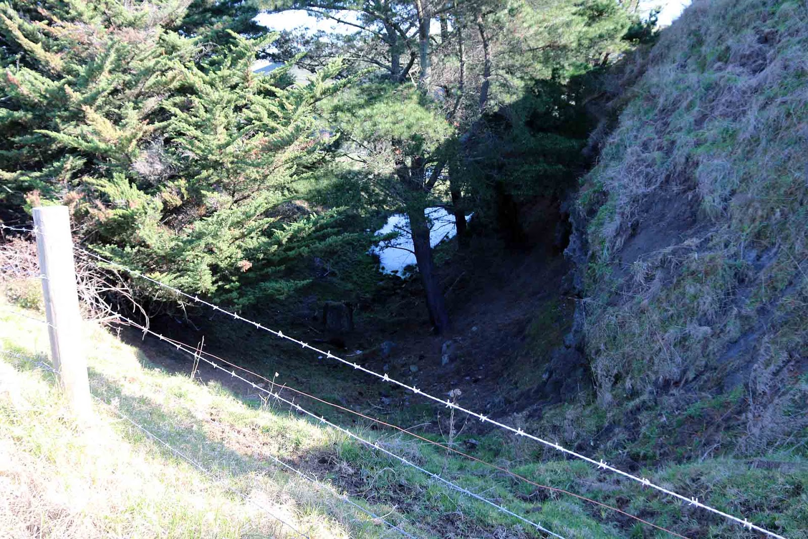
From near the site of the high bridge (behind me), looking back across the embankment to the cutting.
On the East side of the road, the line exited the cutting straight onto this large embankment, containing around 28,000 cubic yards of material. The line can be seen curving around to the right in the distance, to the right of the house and on to the line terminus a short way further on.
Koo Wee Rup to Strzelecki Line - High bridge at Strzelecki. There is no trace of this bridge any longer, it has long gone, but you can still clearly see the bridge abutments. The marker icon in this case marks where the centre of the bridge was.
There is an amusing story told in Merilyn Ramsay's book: "Towards the end of the life of this railway, this bridge was in dire need of maintenance, and eventually the locomotive crew of a train heading towards Strzelecki were so alarmed at the creaking and swaying of the bridge on the down trip, that when returning they were not prepared to ride the train over the bridge. So the driver and guard walked across the bridge, while the firemen set the brake, eased it slightly, and let the train roll across on its own on the down grade. As it finished crossing, the driver swung aboard and stopped the train. The fireman was seen crossing the bridge on his hands and knees!"
However it most likely remains just an amusing story, as the bridge was in a sufficiently safe condition to allow salvage trains to take out the turntable from the terminus, along with the rail.
The bridge sat here for a long time with just the piles in place, the decking having been removed (or stolen!). There were still piles in evidence in the early 70s.
Looking across the gap. The Down end abutment is at the foot of this photo, while the up end is the furthest mound away from the camera, closer to the cutting hidden by the trees.
Turntable With A View. And it sure did, one of the best views in the state. Located past the end of the station site, adjacent to Wild Dog Road, the empty turntable pit was the true end of the road for the Koo Wee Rup to Strzelecki line. It had no roads, simply required to turn the locomotive for its return trip.
How's that for a view. The turntable pit at Strzelecki, still quite evident and the two concrete ends still in place.
Closer shot showing small cutting leading to the pit.
Concrete abutment for the end of the pit, truly the End Of The Line.
Outtrim Coal Mine Area. This was the terminus of the branch, a small valley filled with coal mines. Today, looking at the area, there is a vague suggestion of the busyness of yesteryear, but almost nothing of the mines exist today other than a few adits, some of which are still open. However all are on private land and the owners are not keen to let you go into them. There is a lot of suspicion around here of coal seam gas explorers, and there are signs warning them off.
General view of area. The line emerged from the cutting to the right and passed over an embankment beyond the gate to where the white house has been recently built. The house sits right where the tracks fanned out into s series of sidings. The sheer wall just visible to the right of the house features in the next photo from the past.
Mine area showing sidings and coal loading stages. The sheer wall to the right with the man sitting on it is the same as that at the rear of the present new house. However none of the mine buildings exist today, nor any trace of them. Just behind the man on the wall, tucked around the corner, was one of the main mine entrances.
Photo by John Henry Harvey from the State Library of Victoria collection
Wide shot of mine area. The sheer wall behind the house can clearly be seen now, along with the cutting and banks forming the rail approach to the mines. This whole area was once filled with mine buildings, equipment , huts and such.
This shot is the opposite of the previous present day one, taken from the other side of the valley. The cutting is clearly seen in the top left of the photo, and the valley is filled with mines and equipment.
Photo by John Henry Harvey from the State Library of Victoria collection
Outtrim Cutting. Made famous by the shot of W155, which I have reproduced a copy of here. This deep cutting has now been filled in and the original wooden bridge carrying the road over rail has long gone.
The classic shot showing W155 climbing out of the Outtrim mine area with a full load of coal in tow. The town buildings in the background are also long gone.
Photo by VR Photographer, from Museum Victoria.
The cutting taken from as close as possible to the same position, but no train, no cutting.
The approach to the Outtrim cutting from the opposite direction, seen winding around the hills from the big embankment.
The cutting on the other side of the road, heading off to the Outtrim mine area.
And this is how the road bridge over the cutting looked on January 4, 1955. I can only say I am glad I nver drove across that bridge.
Jumbunna Embankment. Reputedly the largest earthen embankment ever built by the Victorian Railways, and when you stand on it, or its approaches, you are quite humbled by the scale of the thing. I measured it as 194 Metres long, but could not measure the height. It is not easy to get to, you have to ask permission of a landowner even to get to the ROW from anywhere. The landowner I asked to allow me to cross his land was at the nearest house, to the North East of the site. He told me there was a brick lined tunnel right through the middle of the structure to allow for drainiage, and as a child he had walked through there often. I did not go down to the bottom to find out. The locals said the fill was mostly obtained from the long deep cutting just on the Up side. This cutting is approximately 500 Metres long and as deep as 10 Metres in some places. However there is evidence of three small quarry sites either side of the embankment that probably also sourced material.
This shot, taken from the South west on the Outtrim - Moyarra Road, shows the impressive scale of the embankment in the landscape. However some of the right hand end is hidden from view.
This is the Southern end of the long, deep cutting that approaches the embankment. It was not possible to get a good shot showing the size of this cutting, an aerial shot would have been better.
A shot of the Northern approach to the embankment, with the large cutting in the distance. The farm where I obtained access is visible to the top left of the hill.
Reverse shot looking South with the embankment to the left of centre in the distance. Not too impressive from here, but wait, there is more...
The embankment from the northern end. Sadly, this photo does not do it justice in terms of conveying the scale of the thing..
Looking over the edge of the embankment from the middle, on the South Western side.
One of the small quarries used to source fill material. Sadly, some mongrel has dumped a huge load of glass bottles, just visible at bottom right.
And another quarry.
A pair of railway wheels at the North Eastern foot of the embankment. I could not get down there to measure them and find out if they were from a VR vehicle or a mining railway, but there were no mining railways near here and the gauge looks closer to broad gauge. I suspect they may be the axle and wheels from gangers trolley.
This is a more recent aerial view of the embankment, taken in July 2017. Make sure you watch it in full screen and it is available up to 4K resolution if your Internet connection can handle it.
Bridge Over Rees Road in Jumbunna, or what little is left of it. Three piles, one cut of at ground level, is all that is left of this bridge. Those, and the bridge abutment is all there is to suggest a bridge was ever here.
Photo of the Jumbunna Township taken from the hill to the north. The bridge can be seen in middle left of the shot. The piles are at the end nearest to the camera.
Photo by H Taylor Studio, copy from Clare Gleeson, Museum Victoria
This is the bridge as it appeared on January 4, 1955. The line was out of use but the bridge was in good condition.
Photo by Des Jowett
The three piles and the end of the abutment, all that is left of the bridge today.
Korumburra to Outtrim Line - Approach to Jumbunna to the North West of the Jumbunna township. This line is characterised by embankments and cuttings, as it is almost impossible to run a railway through this terrain on the level. On the Up side of Jumbunna there is a long straight section of track alongside the road, coming out of a cutting, in the distance the line crosses to the left hand side of the road to arrive at the old Jumbunna station site, now built over with stock sheds. This line was closed in October 1953.
Looking towards the township of Jumbunna, although little of it now remains. Where you see the white car in the distance on the road, the line crossed over to the left side of the road. I could not help thinking that the power poles need straightening.
Looking back in the opposite direction, the line crosses one of many embankments into yet another cutting, on its way back to Korumburra.
The floor of the cutting directly below the position where I was standing to take the shots.
Road over Rail Bridge Bena Bank. Another case of Steel Strangler Fig infestation, Only in this case, more extreme. This bridge is quite high, I would estimate 6-7 Metres from rail to road. Unfortunately there was no safe way down to rail level to get a shot, as the ground was wet and greasy.
Taken on the South side looking North. Bena is to the right. Like its sister bridges, this is strictly a single lane bridge with stopping point on the North road side if the bridge is occupied.
A good view of the extent of the steel reinforcement. The piles are sitting in concrete encasements with surplus rail used to brace the bridge in every direction.
From under the bridge it can be seen that the bracing is very extensive, however it should be acknowledged that the timber piles are still the main structural elements of this bridge.
Looking up at the decking, two heavy longitudinal I beams can be seen running the length of the bridge, with the road surface still sitting on transverse timbers. Some piles, like the middle one in this trestle, are strapped and filled to prevent moisture getting into the pile and accelerating decay.
Road over Rail Bridge at Jeetho. The smaller of the three bridges in this locality, this bridge carries the Jeetho Road over the rail line at Jeetho. It has not been given the same treatment as the other two bridges, no steel cladding, but it is of a similar design.
View of the roadway taken on the south side looking north. It is clear that I used a flash for this shot, it was a miserable day with fine misty rain.
Looking at the bridge from the North East corner. The Bena Bank begins here and rises to the left of the photo. Note the lack of any steel reinforcement that characterises the other bridges.
At track level looking along the line in the Up direction towards Loch. At the time of taking this photograph, the line is out of use.
From South West corner, showing minor reinforcement of braces.
Trestle on (Former) SEC Rubicon Tramway. The timber trestle was one of two bridges on the former SEC tramway along the aqueducts at Rubicon/Royston. This one has been given recent attention by enthusiasts in order to preserve it.
Photo taken on the south side of the trestle looking north. This was a relatively lightly constructed wooden trestle, as it only had to carry a very light load. The water crosses the valley via a syphon, the pipe is visible to the right of the shot.