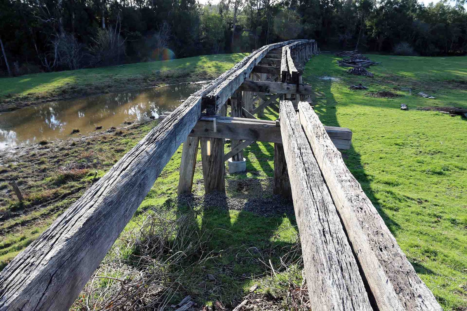
Tarwin River West Branch Bridge 2 at Koonwarra. The second of the two bridges is 146 Metres long including approaches, and is almost identical in construction to the first bridge. It is also being rebuilt in the same way, by repairing the approach trestles and building a new section over the river. The rail trail has been built right up to the Down abutment and then fenced off to keep people like me out of the work site.
Looking West or Up from the Down abutment. This looks to be where the work is currently being focussed, judging by the presence of the lift unit.
View from ground level on the flood plain. I rather fancied that little blue lift, but they had taken the keys. The area is quite soft and large amounts of rock had been spread in the area to make it workable.
Showing the far bridge abutment, going into the cutting. I am not sure what the purpose of the cut-off piles is, as this section is supposed to be new construction.
Wider shot of new bridge area.
Reverse angle shot of the approach spans. The barrier fencing can just be seen at the far end. They appear to be trying to preserve the original structure as much as possible, but I did not see any evidence of new timber being used to replace rotten sections. Perhaps that will be in the next stage of work.
Wide view from the Up end abutment of the full bridge.
Sunday, 14 June 2015
South Gippsland Railway Line - Tarwin River Bridge 1 at Koonwarra
Tarwin River West Branch Bridge 1 at Koonwarra. The two bridges in this group crossed the Tarwin River West Branch twice where it curves around in a loop. In both cases, from the Up end, they cross the river first, then the small flood plain beyond. In between each bridge is a shallow cutting connecting them. The Great Southern Rail Trail is heading inexorably towards these bridges, but this time, instead of building a parallel walkway alongside, as they did at Meeniyan, they are repairing the existing trestle sections across the flood plain and planning a new construction section over the river itself. Equipment was on-site when I visited the bridges, with a temporary aluminium footbridge across the river to get to the middle section. This bridge is 152 Metres long, including approaches, most of which will be the remediated structure. As usual, there were cattle who offered photographic advice - like in Go Take Them Pictures Elsewhere!
Looking along the (missing) deck towards the river. The structure that now exists appears to be the parts that have been selected to remain. Note piles partly encased in cement, an interesting practice as I am told it simply accelerates the decay.
Side view, with piles of discarded bridge components in the right distance, and the West bank of the river in the dark area.
Looking back from the river to the cutting in the over-exposed area of the shot. The concrete block in the foreground will form the foundation for the new bridge structure across the river.
Looking across the river to the Up side with the new bridge foundation footing evident and the abutment prepared for the new bridge.
Showing the extent of the remediated bridge section, and the piles of discarded components to the left.
Looking along the (missing) deck towards the river. The structure that now exists appears to be the parts that have been selected to remain. Note piles partly encased in cement, an interesting practice as I am told it simply accelerates the decay.
Side view, with piles of discarded bridge components in the right distance, and the West bank of the river in the dark area.
Looking back from the river to the cutting in the over-exposed area of the shot. The concrete block in the foreground will form the foundation for the new bridge structure across the river.
Looking across the river to the Up side with the new bridge foundation footing evident and the abutment prepared for the new bridge.
Showing the extent of the remediated bridge section, and the piles of discarded components to the left.
Tuesday, 9 June 2015
Noojee Line - Intersection with Laing Road
Noojee Line - Intersection with Laing Road. I was looking to try and identify the owners of the land where the sites of Bridges 1 and 2 are located, and it provided an interesting place to view the ROW from.
Looking East along the ROW at Laing Road. The track curved around to the right behind the hill in the mid foreground to the site of Bridge Number 1. It then comes back on the far side of the gully, heading towards the famous Bridge Number 2.
Looking towards Bridge Number 2. The line curves around to the notch in the hill with the bright green grass, passing around the far side of the hill to its appointment with Bridge 2 in the far gully, now filled with lush vegetation and trees.
Looking back towards Nayook from Laing Road. The line curves away to the right, then curving back around the hill towards Nayook to the left of the shot.
Looking East along the ROW at Laing Road. The track curved around to the right behind the hill in the mid foreground to the site of Bridge Number 1. It then comes back on the far side of the gully, heading towards the famous Bridge Number 2.
Looking towards Bridge Number 2. The line curves around to the notch in the hill with the bright green grass, passing around the far side of the hill to its appointment with Bridge 2 in the far gully, now filled with lush vegetation and trees.
Looking back towards Nayook from Laing Road. The line curves away to the right, then curving back around the hill towards Nayook to the left of the shot.
Noojee Line - Road Over Rail Bridge at Crossover
Noojee Line - Road Over Rail Bridge at Crossover. Another quite famous and heritage listed bridge. It is situated in a very deep cutting, 15 Metres deep in fact, that was reputed to be the deepest hand excavated cutting on the VR at the time of its construction in 1892. The bridge spans 40 Metres with 7 openings. The bridge was closed to traffic in 1968, supposedly due to failure of some structural components, but in any event, Bloomfield Road was re-aligned prior to this making the bridge un-necessary. Despite its heritage listing, no attempts seem to have been made to repair or restore any parts of the bridge. It is now closed to pedestrians from above and below, although there is a walking track down to the ROW on the Western side, accessed from Bridge Road.
The bridge as it was in 1948, prior to the closure of the line. Only a mere 56 years old then.
ts grass covered surface basking in the Winter sun, the bridge looks very sad today. Interesting to note that the transverse deck timbers are laid in a skewed pattern, I am guessing this is to lessen impact damage from heavy logging trucks.
View from the Eastern Side, where there is a small parking area.
View from the Western side, accessed via Bridge Road. Most parts of the bridge are still in position, even though they may be rotten.
View from down at track level, sag in the bridge is readily apparent from this angle. However it is good to remember that it has been in place now for 123 years!
Low angle view looking up at the deck. Bit of a crafty-arty-farty shot, but this time it came off.
This bridge was pretty solidly built to take heavy logging traffic.
A great testimony to its builders that the bridge is still standing after 123 years, despite probably having no maintenance since the 1950s.
I am guessing no-one is expected to venture further down the ROW, as it is pretty blocked beyond the bridge.
OK, just one more clever-dick shot. Notice the broken outer stay on the left, while the right side one is missing altogether.
The bridge as it was in 1948, prior to the closure of the line. Only a mere 56 years old then.
![]() |
| Photo origin unknown. Possibly Victorian Railways. |
View from the Eastern Side, where there is a small parking area.
View from the Western side, accessed via Bridge Road. Most parts of the bridge are still in position, even though they may be rotten.
View from down at track level, sag in the bridge is readily apparent from this angle. However it is good to remember that it has been in place now for 123 years!
Low angle view looking up at the deck. Bit of a crafty-arty-farty shot, but this time it came off.
This bridge was pretty solidly built to take heavy logging traffic.
A great testimony to its builders that the bridge is still standing after 123 years, despite probably having no maintenance since the 1950s.
I am guessing no-one is expected to venture further down the ROW, as it is pretty blocked beyond the bridge.
OK, just one more clever-dick shot. Notice the broken outer stay on the left, while the right side one is missing altogether.
Friday, 5 June 2015
South Gippsland Railway - Bena Road over rail bridge
The Bena Road Over Rail Bridge. This bridge was originally a timber trestle bridge over the rail line, but has since suffered a peculiar case of Steel Strangler Fig. The original timber piles are still there, but the bridge has been progressively encased in steel such that the timbers probably take no part in the structural process any longer, and are just going along for the ride.
Lets play Spot The Wooden Bits!
Ah, there are the wooden bits, in the roadway. Clever devils, hiding them out in the open like that.
A free-standing footbridge has been added on the Up side to help disguise the bridge further.
Towards Korumburra in the Down direction, the new bridge over the road is in the over-exposed section, a short distance away.
In itself a rather amazing construction. Fancy building a brand new bridge like this on a railway line with a dubious future? It crosses the old South Gippsland Highway at Bena.
Lets play Spot The Wooden Bits!
Ah, there are the wooden bits, in the roadway. Clever devils, hiding them out in the open like that.
A free-standing footbridge has been added on the Up side to help disguise the bridge further.
Towards Korumburra in the Down direction, the new bridge over the road is in the over-exposed section, a short distance away.
In itself a rather amazing construction. Fancy building a brand new bridge like this on a railway line with a dubious future? It crosses the old South Gippsland Highway at Bena.
South Gippsland Railway - Bridge over Allsop's Creek
South Gippsland Railway Bridge over Allsop's Creek. A similar bridge to the Bass River bridge, only 300 Metres away, perhaps not as high and also maybe a bit longer. Same method of construction. My original plan was to access this bridge by walking over the Bass River bridge, but one look down and I decided Not This Little Black Duck! I woosed out and went to the Loch station site and walked back to the bridge. I met a wombat along the way, he laughed at me, the word had spread already.
Looking across the bridge towards Nyora, showing the poor state of some of the transom timbers.
View from below, again looking towards Nyora.
Looking across the bridge towards Nyora, showing the poor state of some of the transom timbers.
View from below, again looking towards Nyora.
South Gippsland Railway - Bridge over Bass River
South Gippsland Railway Bridge over Bass River. The Bass River cuts a fairly deep gorge through the countryside, so the bridges tend to be quite substantial, and this one is no exception. So also does the nearby bridge on the Wonthaggi Branch and also the Allsops Creek bridge, a short 300 Metres away. However unlike the bridge on the Wonthaggi Branch, these bridges have no timber deck, the sleepers, or more correctly transom timbers, are bolted directly to the upper side of the span girders and the track spiked to the timbers. There is no ballast on the bridge and being able to see into the river gorge between each timber is a bit scary. I imagine this makes repairs to the deck a bit more difficult, as rotten timbers would have to have the spikes drawn, then the securing bolts unscrewed or cut, and a new timber inserted from the side. Not the easiest task to perform. At the time, this section of the line is not being used, the SGR reports that running is suspended pending track and bridge works, and these bridges may be part of that.
An oblique view, showing the depth of the river gorge. Note the sleepers bolted to the span girders.
Side view of the bridge, taken from Up end, looking towards Loch.
View across the bridge, looking towards Loch.
An oblique view, showing the depth of the river gorge. Note the sleepers bolted to the span girders.
Side view of the bridge, taken from Up end, looking towards Loch.
View across the bridge, looking towards Loch.
Sunday, 31 May 2015
South Gippsland Railway Line - Bridge at 34.69 Km
The bridge at 34.69 Km from Cranbourne is a substantial modern bridge with cast concrete piers, steel spans and wooden transverse deck. It has three openings and is 24 Metres long with a height above water of 3.4 Metres. It bridges a small water or creek with no name. The bridge appears to be in excellent condition.
View across the deck, looking in the Up direction. Just on the far side there was a four foot long Brown Snake taking advantage of the last rays of Autumn sun.
View of the span and deck structure.
View from the opposite side.
View across the deck, looking in the Up direction. Just on the far side there was a four foot long Brown Snake taking advantage of the last rays of Autumn sun.
View of the span and deck structure.
View from the opposite side.
Saturday, 30 May 2015
Wonthaggi Branch Bridge Number 2 - Bass River
Wonthaggi Branch Bridge Number 2 - Bass River, is a quite large bridge, probably only second in size to the famed Kilcunda Trestle and is entirely modern in construction. It is of virtually identical construction to the nearby bridges on the South Gippsland line over the same river and also over Allsop's Creek. It consists of four tall cast concrete piers with a long centre span and steel beams. The deck is transverse wooden construction. The bridge is located 4.32 Km from Nyora and is 56 Metres long and approximately 14 Metres above the water. Part of the transverse wooden deck has collapsed, but otherwise it is in good condition. It is certain this is not the original bridge, as the approach is dog-legged as if the straight approach was for a previous bridge, and it is documented that the original line had temporary bridges in order to construct the branch quickly.
Shows the approach to the Bass River Bridge in the distance. You can just make out the slight curve to the left, closer to the brown bull, rather than the straight alignment. And yes, he was a bull. We had an agreement, I was not interested in his cows, and he was not interested in me.
Across the deck. The rotten section is near the dead shrub, which is over one of the massive centre piers. Quite un-nerving to look through the hole for someone with acrophobia. The gate in the foreground has been muscled by the cattle, and wombats have been doing their best to undermine the piers.
Western side of Up abutment, looking towards the Down end. The two piers on this side are clearly seen, the other side is a mirror of this.
As clear a view as I could obtain of the central piers and span. Future trips might involve carrying a chainsaw.
A wider view taken from down closer to the river, showing the piers and span on the far side.
Shows the approach to the Bass River Bridge in the distance. You can just make out the slight curve to the left, closer to the brown bull, rather than the straight alignment. And yes, he was a bull. We had an agreement, I was not interested in his cows, and he was not interested in me.
Across the deck. The rotten section is near the dead shrub, which is over one of the massive centre piers. Quite un-nerving to look through the hole for someone with acrophobia. The gate in the foreground has been muscled by the cattle, and wombats have been doing their best to undermine the piers.
Western side of Up abutment, looking towards the Down end. The two piers on this side are clearly seen, the other side is a mirror of this.
As clear a view as I could obtain of the central piers and span. Future trips might involve carrying a chainsaw.
A wider view taken from down closer to the river, showing the piers and span on the far side.
Wonthaggi Branch - Bridge Number 1
Wonthaggi Branch Bridge Number 1 crosses a small creek of no name. It is constructed with four cast concrete piers and a wooden deck with longitudinal wooden beams, some of which have been replaced by rail sections. It would originally have served as a cattle crossing. It is located 3.90 Km from Nyora, is 14.7 Metres long with a height of 2.6 Metres.
Looking across the bridge in the Down direction.
Western side on Up side of watercourse.
Eastern side on Up side of watercourse.
Looking across the bridge in the Down direction.
Western side on Up side of watercourse.
Eastern side on Up side of watercourse.
Wonthaggi Branch - Nyora Bank
Wonthaggi Branch Nyora Bank was a section of line that was regraded after construction to make it easier on Up trains with coal loads. A disadvantage of making the Wonthaggi Branch diverge at Nyora is the necessity to climb up a hill then down again, when a better route might have been taken to the west from Lang Lang. As a result, shortly after the line was built it was regraded. Berrys Road was redirected to cross over the line near the foot of the bank, and these photos are taken at the crossing.
The crossing is 3.28 Km from Nyora, this shot looks back up the bank in the Up direction. In the distance, the line curves around to the left and enters a deep cutting before running parallel to the South Gippsland line for the run into Nyora.
Looking in the opposite direction, down the bank towards the Bass River in the distance.
The crossing is 3.28 Km from Nyora, this shot looks back up the bank in the Up direction. In the distance, the line curves around to the left and enters a deep cutting before running parallel to the South Gippsland line for the run into Nyora.
Looking in the opposite direction, down the bank towards the Bass River in the distance.
Monday, 25 May 2015
South Gippsland Railway Line - Lang Lang Station
Lang Lang Station exists as a platform, a passing road and a few small relics. The township of Lang Lang seems to look after the area as if it may one day be resurrected, and maybe it will. There is some logic in running an electrified service as far as Lang Lang to serve the expanding metropolitan area.
Looking in the Down direction towards the station, with the crossing at Westernport Road in the foreground. Some of the now redundant electrical cabinets are still there, the points to the second road are visible across the roadway, with the platform in the distance. The box cover over the signal ladder is clearly visible.
The well photographed remains of the lever frame on the platform.
Looking in the Down direction towards the station, with the crossing at Westernport Road in the foreground. Some of the now redundant electrical cabinets are still there, the points to the second road are visible across the roadway, with the platform in the distance. The box cover over the signal ladder is clearly visible.
An often repeated view of the station platform, decaying but still there and surfaced in bitumen. The small Cocker Spaniel is Georgia, who accompanies me on these trips. She can sniff out a rail relic at a hundred paces, works cheap and runs on Fish N Chips, just like me.
The well photographed remains of the lever frame on the platform.
South Gippsland Railway Line - Lang Lang Down Home Signal
The Lang Lang Down Home Signal is still in place, a classic lattice mast, but the lamp and other fittings have long gone. The Nanny brigade have now fastened a steel box across the ladder to make it harder to climb
View of the signal looking in the Down direction towards Lang Lang Station.
Subscribe to:
Posts (Atom)